Old Maps of Pike County, Indiana for Hiking & Exploration
Hike through history with 106 historic maps of Pike County. Explore old trails, ghost towns, and forgotten backroads — perfect for outdoor adventurers and local explorers.
- Rediscover forgotten places: Map out old mining camps, roads, and footpaths that no longer exist on modern maps.
- Layer with modern tools: Combine with LiDAR or satellite views to plan hikes through historical terrain.
- Made for exploration: Popular among hikers, overlanders, and local history lovers.
Use these maps to find adventure and explore the hidden past of Pike County.
Pike County, IN maps
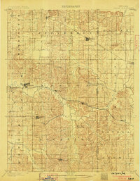
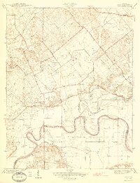
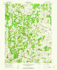
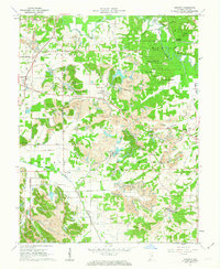
(106)- 1900 Map of De Gonia Springs, 1963 Print
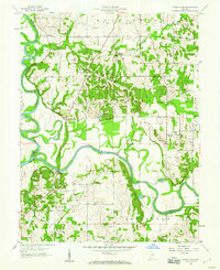
 1900 De Gonia Springs1963 Print · USGSSouthern Indiana at the turn of the century shows a landscape of rail-dependent towns and mineral spring resorts across Warrick and Spencer counties. Genealogists and historians can trace the early layouts of De Gonia Springs, Folsomville, and Tennyson along the SOUTHERN railroad lines.
 - 1902 Map of Ditney
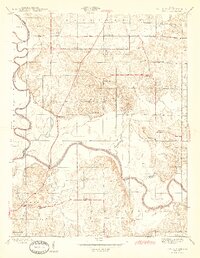
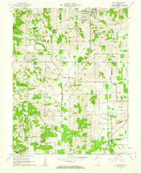
 1902 Ditney1902 Print · USGSSouthern Indiana at the start of the century was a landscape of expanding railroads and rural hamlets. Family historians can trace ancestral roots through dozens of small settlements like Coats Springs, Dongola, and Boonville along the Southern RR.3 unique versions available
 - 1902 Map of Degonia Springs
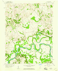
 1902 Degonia Springs1902 Print · USGSSouthwestern Indiana is captured here at the turn of the century as the rail network linked the region's mineral springs and rural townships. Genealogists can trace the early layout of Degonia Springs, Folsomville, and Gentryville along the SOUTHERN railroad lines.2 unique versions available
 - 1902 Map of Boonville
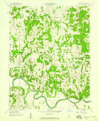
 1902 Boonville1902 Print · USGSWarrick and Gibson Counties at the opening of the twentieth century reveal a landscape of evolving transport and established rural life. Trace the path of the Wabash and Erie Canal or locate family roots in Boonville, Millersburg, and Lynnville.4 unique versions available
 - 1903 Map of Velpen
 1903 Velpen1903 Print · USGSSouthern Indiana at the start of the century was a landscape of river-bottom farms and emerging rail towns along the Patoka River. Genealogists and researchers can trace early township boundaries and find long-established communities like Winslow, Otwell, and the mineral waters of White Sulphur Springs.2 unique versions available
 - 1903 Map of Petersburg
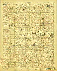 1903 Petersburg1903 Print · USGSSouthwestern Indiana at the turn of the century reveals a landscape shaped by river commerce and the early coal industry. Genealogists can trace family roots in Petersburg or Oakland City, and locate the Erie Canal and Massey Mine.2 unique versions available
 - 1944 Map of Glendale
 1944 Glendale1944 Print · USGSDaviess County during the mid-1940s is defined by the winding East Fork White River and the rural crossroads of the Indiana countryside. Researchers can trace ancestral roots through local landmarks like Glencoe Cem, Pennyville, and a Coal Mine near High Rock.2 unique versions available
 - 1944 Map of Monroe City
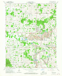
 1944 Monroe City1944 Print · USGSMonroe City and the surrounding Knox County bottomlands are captured here in the 1940s, just as the rural landscape was maturing. Researchers can trace family origins through numerous landmarks like Freeland Cemetery, Hamline Chapel, and Slickum School.2 unique versions available
 - 1944 Map of Iona
 1944 Iona1944 Print · USGSKnox and Gibson counties meet along the high-banked curves of the White River in the early 1940s. Researchers can trace rural lineages through numerous local sites including Slow Cem, West Salem Cem, and the settlement at Iona.2 unique versions available
 - 1945 Map of Sandy Hook
 1945 Sandy Hook1945 Print · USGSDaviess County was a landscape of small schoolhouses and river junctions during the 1940s. Genealogists and local historians can trace family locations near Union Cemetery or locate old community centers like Sandy Hook and Needmore Sch.2 unique versions available
 - 1956 Map of Vincennes, 1967 Print
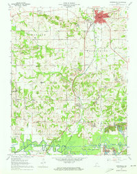
 1956 Vincennes1967 Print · USGSSouthern Indiana and the Illinois borderlands are captured here in the mid-fifties, showing the region's dense network of river towns and rail lines. Researchers can trace historic river crossings along the Wabash River or locate landmarks like Wyandotte Cave and Lincoln State Park.4 unique versions available
 - 1957 Map of Vincennes
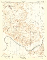
 1957 Vincennes1957 Print · USGSSouthwest Indiana and the Illinois borderlands come alive in the late 1950s, a period of heavy rail traffic and expanding state forests. Genealogists and historians can trace the riverfronts and rail lines of Vincennes, New Harmony, and the vast Crane Naval Ammunition Depot.
 - 1958 Map of Vincennes
 1958 Vincennes1958 Print · USGSSouthern Indiana and the Illinois borderlands are captured during a mid-century period of heavy rail traffic and military activity. Researchers can trace the sprawling bounds of the Crane Naval Ammunition Depot or locate historic settlements like New Harmony and French Lick.2 unique versions available
 - 1958 Map of Monroe City, 1959 Print
 1958 Monroe City1959 Print · USGSThe White River valley and the Beech Hills are captured in the late 1950s, showing a landscape shaped by coal, oil, and the railroad. Genealogists can trace family landmarks like Hamline Chapel, Reels Chapel, and the settlement of Monroe City.2 unique versions available
 - 1958 Map of Iona, 1959 Print
 1958 Iona1959 Print · USGSSouthwestern Indiana farmland meets the serpentine White River in the late fifties, where county lines converge at the water's edge. Genealogists can locate family sites at St Peters Cem or Johnson Cem and trace the rural settlements of Iona and Giro.3 unique versions available
 - 1958 Map of Glendale, 1959 Print
 1958 Glendale1959 Print · USGSDaviess County's southern townships are captured in the late fifties, showing a landscape defined by the winding East Fork White River. Genealogists and local historians can locate rural landmarks like St Patricks Ch, Glencoe Cem, and the community of Glendale.
 - 1958 Map of Sandy Hook, 1960 Print
 1958 Sandy Hook1960 Print · USGSDaviess County at the confluence of the White River forks shows its rural character during the late fifties. Genealogists can trace family connections through numerous landmarks like Union Cemetery, Letts School, and the settlement of Cumback.3 unique versions available
 - 1960 Map of Folsomville, 1963 Print
 1960 Folsomville1963 Print · USGSSouthern Indiana's coal country comes into focus in the early 1960s, showing a landscape defined by the Tecumseh Mine and widespread Strip Mines. Genealogists and historians can trace local landmarks like Dickeyville, the Old Indian Treaty Boundary, and several rural cemeteries.3 unique versions available
 - 1960 Map of Lynnville, 1968 Print
 1960 Lynnville1968 Print · USGSSouthwestern Indiana's coal country comes into sharp focus during the 1960s as industrial excavation meets rural tradition. Researchers can trace the massive Strip Mines alongside local landmarks like Barnetta Chapel, St Pauls Cem, and Graham Valley.5 unique versions available
 - 1961 Map of Otwell, 1962 Print
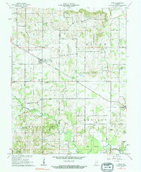 1961 Otwell1962 Print · USGSSouthern Indiana rural life is captured here in the early sixties, centered on the crossroads village of Otwell. Researchers can trace family history through numerous country landmarks like Traylor Union Ch, Chapel Cem, and the Otwell Holiness Camp.3 unique versions available
 - 1961 Map of Velpen, 1962 Print
 1961 Velpen1962 Print · USGSThe border of Pike and Dubois counties comes alive in the early sixties as a landscape of timbered ridges, coal-country oil wells, and quiet hamlets. Genealogists and hikers can locate family landmarks like Stillwell Cem, the local Covered Bridge, and the community of Pikeville.2 unique versions available
 - 1961 Map of Holland, 1962 Print
 1961 Holland1962 Print · USGSThe crossroads of Dubois, Warrick, and Spencer counties come alive in the early sixties as rural life meets emerging industry. Researchers can trace the Old Indian Treaty Boundary and locate family burial sites like St James Cem or the Strip Mine near Selvin.3 unique versions available
 - 1961 Map of Petersburg, 1963 Print
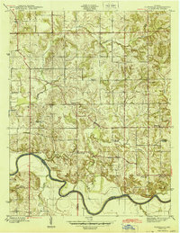
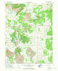
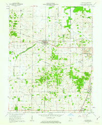
 1961 Petersburg1963 Print · USGSPike County at the start of the sixties shows a landscape defined by the White River and a deep network of coal and rail infrastructure. Genealogists can locate numerous rural burial grounds like Old Town Cem and family chapels including Gladish Chapel.3 unique versions available
 - 1961 Map of Francisco, 1963 Print
 1961 Francisco1963 Print · USGSGibson County at the start of the sixties reveals a landscape of rural townships and evolving industry. Genealogists and local historians can trace family church sites like Providence Ch, explore the small town of Francisco, and locate the Old Indian Treaty Boundary.3 unique versions available
 - 1961 Map of Augusta, 1963 Print
 1961 Augusta1963 Print · USGSSouthern Indiana in the early sixties reveals a landscape of transition between coal extraction and conservation. Genealogists and historians can locate family landmarks like Ashby Ch, the Odd Fellows Cem, and the historic Indian Treaty Boundary.5 unique versions available
Showing maps 1-25 of 106
Top cities of Pike County
Frequently asked questions
- What are the different types of historical maps available for Pike County?
- What is the oldest map of Pike County?
- Where can I purchase historical maps of Pike County for my home or office?
- Where can I download high-res historical maps of Pike County?
- Are there historical topographic maps available for Pike County?
- Is there historical aerial imagery available for Pike County?
- Where are historical maps of Pike County sourced from?