1900s (20th Century) Maps of Coburg, Indiana
Explore 6 historic maps of Coburg from the 1900s (20th Century). These maps offer a rare glimpse into what life looked like during the 1900s — showing old roads, neighborhoods, homes, and landmarks that have changed or disappeared over time.
Whether you're researching your family's past, planning a metal detecting trip, or studying how Coburg's landscape evolved across the 1900s, these high-resolution maps are a powerful tool for exploring the history of this region.
- Focus on a specific era: All maps on this page are from the 1900s, giving you a focused view of this time period.
- See what’s changed: Compare century-old streets, trails, and buildings to today's modern landscape using overlays and satellite layers.
- Research with precision: Use these maps for genealogy, historical research, land use analysis, or educational projects.
- View, download, or print: Maps are fully viewable online in high resolution, and can be downloaded or printed for your own records.
Start exploring Coburg's history through authentic maps from the 1900s. This is your window into the past.
Coburg, IN maps
(6)- 1953 Map of Westville, 1955 Print
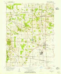 1953 Westville1955 Print · USGSLaPorte and Porter counties in the early fifties show a landscape defined by industrial rail corridors and institutional development. Researchers can trace the sprawling grounds of Beatty Memorial Hospital and old pioneer sites like Quakerdom Cem or Eight Square Cem.
 - 1953 Map of Chicago, 1964 Print
 1953 Chicago1964 Print · USGSThe southern Lake Michigan shoreline was rapidly modernizing in the mid-fifties, balancing heavy industry with its famous academic centers. Researchers can trace the footprints of Notre Dame University or locate vanished sites like the Kingsbury Ordnance Plant and Meigs Field.5 unique versions available
 - 1957 Map of Chicago
 1957 Chicago1957 Print · USGSThe industrial heartland and southern Great Lakes shoreline are captured here during the peak of mid-century growth. Researchers can trace the massive Gary Steel Works, the grounds of the University of Notre Dame, and the early paths of the Tri-State Tollway.
 - 1962 Map of Westville, 1964 Print
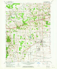 1962 Westville1964 Print · USGSWestville and the surrounding townships are shown at a peak of rail and institutional development during the early sixties. Genealogists and local historians can trace family roots through the Quakerdom Cem, the Eight-Square Ch, and old stops at Burdick and Coburg.
 - 1969 Map of Westville, 1971 Print
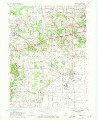 1969 Westville1971 Print · USGSNear the Porter and La Porte county line in the early seventies, this area shows a landscape defined by major rail lines and rising institutions. Genealogists and local historians can trace family plots at Quakerdom Cem or locate the sprawling Beatty Memorial Hospital and the nearby State Prison Farm.2 unique versions available
 - 1983 Map of South Bend, 1984 Print
 1983 South Bend1984 Print · USGSThe Indiana-Michigan borderlands come alive in this early 1980s overview of the Michiana region's industrial and academic hubs. Researchers can trace the rail networks of Conrail and the Grand Trunk Western alongside landmarks like the University of Notre Dame and Indiana Dunes State Park.2 unique versions available
End of results
Showing maps 1-6 of 6
Top cities near Coburg
- Portage historical maps
- Valparaiso historical maps
- Michigan City historical maps
- La Porte historical maps
- Chesterton historical maps
- Porter historical maps
See more
Frequently asked questions
- What are the different types of historical maps available for Coburg?
- What is the oldest map of Coburg?
- Where can I purchase historical maps of Coburg for my home or office?
- Where can I download high-res historical maps of Coburg?
- Are there historical topographic maps available for Coburg?
- Is there historical aerial imagery available for Coburg?
- Where are historical maps of Coburg sourced from?