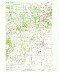
1969 Map of Westville
USGS Topo · Published 1971About this map
The Little Calumet River meanders across this landscape on the border of Porter and La Porte counties, where industrial infrastructure and academic expansion meet the rural Indiana countryside. At the heart of the quadrangle lies Westville, a crossroads defined by the intersection of the Norfolk and Western, Penn Central, and Baltimore and Ohio railroads. The late 1960s saw significant institutional growth here, most notably with the development of the Purdue University North Central Campus and the expansive grounds of the Beatty Memorial Hospital.
Find a feature on this map
54 named features on this map. Tap any name to fly to it.
Don’t see what you’re looking for? This feature index may not catch every label — zoom into the map to look around manually.
Map Details
Editions of this 1969 Westville Map
2 editions found
Other maps of this area

1934 · Porter
USGS Topo · 1:48,000

1940 · Porter
USGS Topo · 1:62,500

1953 · Wanatah
USGS Topo · 1:24,000

1953 · Westville
USGS Topo · 1:24,000

1953 · Valparaiso
USGS Topo · 1:24,000

1953 · Chesterton
USGS Topo · 1:24,000

1953 · Dune Acres
USGS Topo · 1:24,000

1953 · Michigan City West
USGS Topo · 1:24,000

1953 · Chicago
USGS Topo · 1:250,000

1957 · Chicago
USGS Topo · 1:250,000