1990s Maps of Randolph County, Indiana
Explore 2 historic maps of Randolph County from the 1990s. These maps offer a rare glimpse into what life looked like during the 1990s — showing old roads, neighborhoods, homes, and landmarks that have changed or disappeared over time.
Whether you're researching your family's past, planning a metal detecting trip, or studying how Randolph County's landscape evolved across the 1990s, these high-resolution maps are a powerful tool for exploring the history of this region.
- Focus on a specific era: All maps on this page are from the 1990s, giving you a focused view of this time period.
- See what’s changed: Compare century-old streets, trails, and buildings to today's modern landscape using overlays and satellite layers.
- Research with precision: Use these maps for genealogy, historical research, land use analysis, or educational projects.
- View, download, or print: Maps are fully viewable online in high resolution, and can be downloaded or printed for your own records.
Start exploring Randolph County's history through authentic maps from the 1990s. This is your window into the past.
Randolph County, IN maps
(2)- 1992 Map of Deerfield, 1995 Print
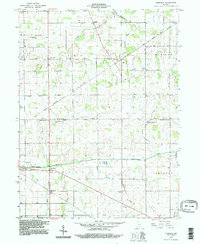 1992 Deerfield1995 Print · USGSThe rural borderlands of Jay and Randolph Counties were documented in the 1990s as a landscape of river-fed farms and diagonal treaty lines. Genealogists can trace family roots through numerous sites like Lawn Dale Cemetery and Zion Church near the Mississinewa River.
 - 1992 Map of Spartanburg, 1995 Print
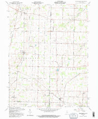 1992 Spartanburg1995 Print · USGSThe Indiana-Ohio borderlands near the close of the twentieth century remain a landscape of small farming hamlets and historic township lines. Genealogists can trace family roots through sites like Beech Ch, Clemens Cem, and the old settlement at Arba.
End of results
Showing maps 1-2 of 2
Top cities of Randolph County
- Winchester historical maps
- Union City historical maps
- Farmland historical maps
- Parker City historical maps
- Lynn historical maps
- Ridgeville historical maps
See more
Frequently asked questions
- What are the different types of historical maps available for Randolph County?
- What is the oldest map of Randolph County?
- Where can I purchase historical maps of Randolph County for my home or office?
- Where can I download high-res historical maps of Randolph County?
- Are there historical topographic maps available for Randolph County?
- Is there historical aerial imagery available for Randolph County?
- Where are historical maps of Randolph County sourced from?