1960s Maps of Saint Joseph County, Indiana
Explore 7 historic maps of Saint Joseph County from the 1960s. These maps offer a rare glimpse into what life looked like during the 1960s — showing old roads, neighborhoods, homes, and landmarks that have changed or disappeared over time.
Whether you're researching your family's past, planning a metal detecting trip, or studying how Saint Joseph County's landscape evolved across the 1960s, these high-resolution maps are a powerful tool for exploring the history of this region.
- Focus on a specific era: All maps on this page are from the 1960s, giving you a focused view of this time period.
- See what’s changed: Compare century-old streets, trails, and buildings to today's modern landscape using overlays and satellite layers.
- Research with precision: Use these maps for genealogy, historical research, land use analysis, or educational projects.
- View, download, or print: Maps are fully viewable online in high resolution, and can be downloaded or printed for your own records.
Start exploring Saint Joseph County's history through authentic maps from the 1960s. This is your window into the past.
Saint Joseph County, IN maps
(7)- 1961 Map of Wakarusa, 1963 Print
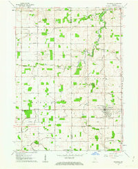 1961 Wakarusa1963 Print · USGSIn the early 1960s, the rural borderlands of Elkhart and St. Joseph counties remained a landscape of family-named drainage ditches and country congregations. Genealogists and local researchers can trace the vicinity of Wakarusa to find Holdeman Ch, Resthaven Cem, and Township High Sch.3 unique versions available
 - 1961 Map of Wyatt, 1964 Print
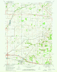
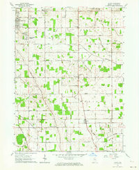 1961 Wyatt1964 Print · USGSSt. Joseph County's rural townships and growing suburban additions are captured in the early 1960s. Researchers can trace local lineage through Union Church Cemetery and landmark institutions like Tamarack Grange or Hay School.2 unique versions available
 - 1969 Map of South Bend East, 1971 Print
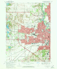
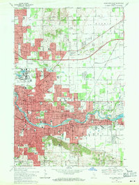 1969 South Bend East1971 Print · USGSSouth Bend and Mishawaka are seen here at the close of the 1960s, a period of major collegiate expansion and urban density along the St Joseph River. Researchers can trace the mid-century footprints of the University of Notre Dame and identify local landmarks like the Grand Trunk rail lines and Cedar Grove Cem.4 unique versions available
 - 1969 Map of Lydick, 1971 Print
 1969 Lydick1971 Print · USGSSt. Joseph County's industrial and rail corridor is captured here in the late sixties, showing the development between South Bend and the county line. Researchers can trace historic settlements like New Carlisle and Crumstown or locate the St Stanislaus Ch and Bendix Woods Park.2 unique versions available
 - 1969 Map of South Bend West, 1971 Print
 1969 South Bend West1971 Print · USGSSouth Bend was expanding rapidly in the late sixties as new highway bypasses began to reshape the outskirts of the city. Genealogists and local historians can trace parish boundaries through numerous schools like St Adalbert Sch or locate family plots in Highland Cemetery and Riverview Cem.4 unique versions available
 - 1969 Map of Osceola, 1971 Print
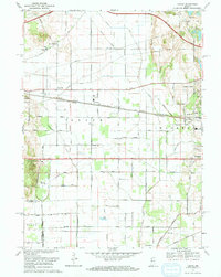
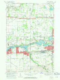 1969 Osceola1971 Print · USGSThe riverfront communities of northern Indiana were expanding rapidly in the late sixties as suburban development met traditional farmland. Genealogists and local historians can trace the foundations of Osceola and Granger, locating family sites near Chapel Hill Memorial Gardens or the Penn Central rail line.4 unique versions available
 - 1969 Map of Hamlet, 1971 Print
 1969 Hamlet1971 Print · USGSStarke and La Porte counties are captured here in the late sixties as the rail-centered economy of Hamlet remained the focal point of the local landscape. Genealogists and researchers can trace the Penn Central lines, the historic Yellowstone Trail, and landmarks like the Township Sch and Grovertown.2 unique versions available
End of results
Showing maps 1-7 of 7
Top cities of Saint Joseph County
- South Bend historical maps
- Mishawaka historical maps
- Granger historical maps
- Notre Dame historical maps
- Olive historical maps
- Osceola historical maps
See more
Frequently asked questions
- What are the different types of historical maps available for Saint Joseph County?
- What is the oldest map of Saint Joseph County?
- Where can I purchase historical maps of Saint Joseph County for my home or office?
- Where can I download high-res historical maps of Saint Joseph County?
- Are there historical topographic maps available for Saint Joseph County?
- Is there historical aerial imagery available for Saint Joseph County?
- Where are historical maps of Saint Joseph County sourced from?