1900-1909 Maps of Spencer County, Indiana
Explore 8 historic maps of Spencer County from 1900-1909. These maps offer a rare glimpse into what life looked like during the 1900s — showing old roads, neighborhoods, homes, and landmarks that have changed or disappeared over time.
Whether you're researching your family's past, planning a metal detecting trip, or studying how Spencer County's landscape evolved across the 1900s, these high-resolution maps are a powerful tool for exploring the history of this region.
- Focus on a specific era: All maps on this page are from the 1900s, giving you a focused view of this time period.
- See what’s changed: Compare century-old streets, trails, and buildings to today's modern landscape using overlays and satellite layers.
- Research with precision: Use these maps for genealogy, historical research, land use analysis, or educational projects.
- View, download, or print: Maps are fully viewable online in high resolution, and can be downloaded or printed for your own records.
Start exploring Spencer County's history through authentic maps from the 1900s. This is your window into the past.
Spencer County, IN maps
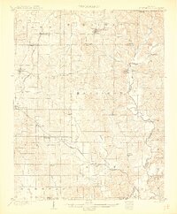
(8)- 1900 Map of St Meinrad, 1961 Print
 1900 St Meinrad1961 Print · USGSSouthern Indiana at the turn of the century shows a landscape of growing rail towns and river crossings. Genealogists can trace family roots through early settlements like Santa Claus, St. Meinrad, and Mariah Hill, or locate landmarks such as Old Mill Fd.
 - 1900 Map of De Gonia Springs, 1963 Print
 1900 De Gonia Springs1963 Print · USGSSouthern Indiana at the turn of the century shows a landscape of rail-dependent towns and mineral spring resorts across Warrick and Spencer counties. Genealogists and historians can trace the early layouts of De Gonia Springs, Folsomville, and Tennyson along the SOUTHERN railroad lines.
 - 1901 Map of Owensboro
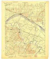
 1901 Owensboro1901 Print · USGSThe Ohio River bend at the turn of the century shows a bustling corridor of rail and river commerce between Kentucky and Indiana. Trace the early footprints of Owensboro and Rockport alongside vanished landmarks like Lake Mills and the Willow Pond Bed.5 unique versions available
 - 1902 Map of Ditney
 1902 Ditney1902 Print · USGSSouthern Indiana at the start of the century was a landscape of expanding railroads and rural hamlets. Family historians can trace ancestral roots through dozens of small settlements like Coats Springs, Dongola, and Boonville along the Southern RR.3 unique versions available
 - 1902 Map of Degonia Springs
 1902 Degonia Springs1902 Print · USGSSouthwestern Indiana is captured here at the turn of the century as the rail network linked the region's mineral springs and rural townships. Genealogists can trace the early layout of Degonia Springs, Folsomville, and Gentryville along the SOUTHERN railroad lines.2 unique versions available
 - 1903 Map of St. Meinrad
 1903 St. Meinrad1903 Print · USGSSouthern Indiana at the start of the twentieth century shows a landscape of rail-connected villages and the winding Anderson River. Trace the early routes of the Southern railway through Lincoln City or locate the original sites of Santa Claus and St.Meinrad.2 unique versions available
 - 1903 Map of Tell City
 1903 Tell City1903 Print · USGSThe Ohio River valley at the turn of the century is captured here as a vital corridor for both river and rail trade. Researchers can trace the early layouts of Tell City and Hawesville or locate smaller settlements like Knottsville and Waitman.7 unique versions available
 - 1905 Map of Newburg
 1905 Newburg1905 Print · USGSThe Ohio River bottomlands of Indiana and Kentucky are captured here in the early twentieth century, showing a world defined by river transit and rail. Genealogists can locate river-town homesteads near Newburg or trace family river crossings at MASON FERRY and HAMILTON FERRY.3 unique versions available
End of results
Showing maps 1-8 of 8
Top cities of Spencer County
- Rockport historical maps
- Dale historical maps
- Grandview historical maps
- Chrisney historical maps
- Gentryville historical maps
Frequently asked questions
- What are the different types of historical maps available for Spencer County?
- What is the oldest map of Spencer County?
- Where can I purchase historical maps of Spencer County for my home or office?
- Where can I download high-res historical maps of Spencer County?
- Are there historical topographic maps available for Spencer County?
- Is there historical aerial imagery available for Spencer County?
- Where are historical maps of Spencer County sourced from?