1990s Maps of Tippecanoe County, Indiana
Explore 3 historic maps of Tippecanoe County from the 1990s. These maps offer a rare glimpse into what life looked like during the 1990s — showing old roads, neighborhoods, homes, and landmarks that have changed or disappeared over time.
Whether you're researching your family's past, planning a metal detecting trip, or studying how Tippecanoe County's landscape evolved across the 1990s, these high-resolution maps are a powerful tool for exploring the history of this region.
- Focus on a specific era: All maps on this page are from the 1990s, giving you a focused view of this time period.
- See what’s changed: Compare century-old streets, trails, and buildings to today's modern landscape using overlays and satellite layers.
- Research with precision: Use these maps for genealogy, historical research, land use analysis, or educational projects.
- View, download, or print: Maps are fully viewable online in high resolution, and can be downloaded or printed for your own records.
Start exploring Tippecanoe County's history through authentic maps from the 1990s. This is your window into the past.
Tippecanoe County, IN maps
(3)- 1990 Map of Watseka, 1991 Print
 1990 Watseka1991 Print · USGSThe Illinois and Indiana borderlands are captured here in the early nineties, showing a landscape defined by prairie drainage and rail lines. You can trace family roots through settlements like L'Erable and Raub or locate landmarks such as Saint Josephs College.
 - 1998 Map of Lafayette West, 2001 Print
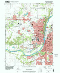 1998 Lafayette West2001 Print · USGSThe West Lafayette and Lafayette area is captured here at the end of the century, centered on the extensive Purdue University campus and riverfront. Researchers can trace historic local sites like St Marys Cem, the Indiana Veterans Home, and the old Norfolk and Western rail lines.
 - 1998 Map of Lafayette East, 2001 Print
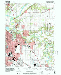 1998 Lafayette East2001 Print · USGSLafayette was rapidly expanding eastward toward the end of the century, merging modern suburban developments with historic river valley terrain. Genealogists and local historians can trace legacy sites like Springvale Cemetery, Bethany Ch, and several rural schools.
End of results
Showing maps 1-3 of 3
Top cities of Tippecanoe County
- Lafayette historical maps
- West Lafayette historical maps
- Shadeland historical maps
- Battle Ground historical maps
- Dayton historical maps
- Clarks Hill historical maps
See more
Frequently asked questions
- What are the different types of historical maps available for Tippecanoe County?
- What is the oldest map of Tippecanoe County?
- Where can I purchase historical maps of Tippecanoe County for my home or office?
- Where can I download high-res historical maps of Tippecanoe County?
- Are there historical topographic maps available for Tippecanoe County?
- Is there historical aerial imagery available for Tippecanoe County?
- Where are historical maps of Tippecanoe County sourced from?