1900s (20th Century) Maps of Melody Hill, Indiana
Explore 12 historic maps of Melody Hill from the 1900s (20th Century). These maps offer a rare glimpse into what life looked like during the 1900s — showing old roads, neighborhoods, homes, and landmarks that have changed or disappeared over time.
Whether you're researching your family's past, planning a metal detecting trip, or studying how Melody Hill's landscape evolved across the 1900s, these high-resolution maps are a powerful tool for exploring the history of this region.
- Focus on a specific era: All maps on this page are from the 1900s, giving you a focused view of this time period.
- See what’s changed: Compare century-old streets, trails, and buildings to today's modern landscape using overlays and satellite layers.
- Research with precision: Use these maps for genealogy, historical research, land use analysis, or educational projects.
- View, download, or print: Maps are fully viewable online in high resolution, and can be downloaded or printed for your own records.
Start exploring Melody Hill's history through authentic maps from the 1900s. This is your window into the past.
Melody Hill, IN maps
(12)- 1901 Map of Haubstadt, 1955 Print
 1901 Haubstadt1955 Print · USGSSouthwestern Indiana thrived as a rail-centric farming region at the turn of the century. Genealogists and historians can trace old property lines and rural crossroads like Parker's Settlement, St. Wendells, and the thriving rail hub at Haubstadt.
 - 1902 Map of Ditney
 1902 Ditney1902 Print · USGSSouthern Indiana at the start of the century was a landscape of expanding railroads and rural hamlets. Family historians can trace ancestral roots through dozens of small settlements like Coats Springs, Dongola, and Boonville along the Southern RR.3 unique versions available
 - 1902 Map of Boonville
 1902 Boonville1902 Print · USGSWarrick and Gibson Counties at the opening of the twentieth century reveal a landscape of evolving transport and established rural life. Trace the path of the Wabash and Erie Canal or locate family roots in Boonville, Millersburg, and Lynnville.4 unique versions available
 - 1903 Map of Haubstadt
 1903 Haubstadt1903 Print · USGSSouthern Indiana at the start of the century shows a landscape of busy rail junctions and tight-knit crossroads. Genealogists can trace family footprints across Parker's Settlement, St. Wendells, and McCutchanville as they appeared before modern road expansion.2 unique versions available
 - 1903 Map of Patoka
 1903 Patoka1903 Print · USGSThe lower Wabash Valley at the start of the twentieth century was a vital crossroads of river trade and rail expansion. Genealogists can trace family roots through settlements like New Harmony and Parker's Settlement or locate the County Farm and Grand Rapids.2 unique versions available
 - 1956 Map of Vincennes, 1967 Print
 1956 Vincennes1967 Print · USGSSouthern Indiana and the Illinois borderlands are captured here in the mid-fifties, showing the region's dense network of river towns and rail lines. Researchers can trace historic river crossings along the Wabash River or locate landmarks like Wyandotte Cave and Lincoln State Park.4 unique versions available
 - 1957 Map of Vincennes
 1957 Vincennes1957 Print · USGSSouthwest Indiana and the Illinois borderlands come alive in the late 1950s, a period of heavy rail traffic and expanding state forests. Genealogists and historians can trace the riverfronts and rail lines of Vincennes, New Harmony, and the vast Crane Naval Ammunition Depot.
 - 1958 Map of Vincennes
 1958 Vincennes1958 Print · USGSSouthern Indiana and the Illinois borderlands are captured during a mid-century period of heavy rail traffic and military activity. Researchers can trace the sprawling bounds of the Crane Naval Ammunition Depot or locate historic settlements like New Harmony and French Lick.2 unique versions available
 - 1961 Map of Daylight, 1963 Print
 1961 Daylight1963 Print · USGSWarrick and Vanderburgh counties are shown in the early sixties as rural life centered on the rail corridors of the New York Central. Researchers can trace the legacy of the Wabash and Erie Canal or locate local landmarks like Daylight Sch and Blue Grass Cem.4 unique versions available
 - 1961 Map of Evansville North, 1963 Print
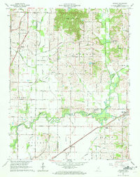
 1961 Evansville North1963 Print · USGSNorth of the city in the early sixties, this area shows the transition from rural Vanderburgh County to suburban neighborhoods and industrial sites. Genealogists can locate family sites near St Joseph Cemetery, Darmstadt, and schools like Rex Mundi High Sch.
 - 1981 Map of Evansville North, 1982 Print
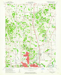
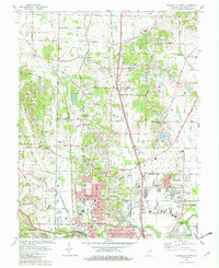 1981 Evansville North1982 Print · USGSNorth of the Ohio River in the early eighties, this survey captures the residential and industrial growth of the Evansville area. Researchers can trace family history through sites like Locust Hill Cemetery, Richter Cem, and the rural enclave of Darmstadt.3 unique versions available
 - 1986 Map of Princeton
 1986 Princeton1986 Print · USGSSouthwestern Indiana is defined by the confluence of the Wabash and White Rivers during the mid-eighties, a period of established rail lines and expanding interstates. Genealogists and historians can trace property locations across numerous townships or locate family sites in Mount Carmel, Poseyville, and Boonville.2 unique versions available
End of results
Showing maps 1-12 of 12
Top cities near Melody Hill
- Evansville historical maps
- Henderson historical maps
- Boonville historical maps
- Newburgh historical maps
- Chandler historical maps
- Armstrong historical maps
See more
Top neighborhoods of Melody Hill
Frequently asked questions
- What are the different types of historical maps available for Melody Hill?
- What is the oldest map of Melody Hill?
- Where can I purchase historical maps of Melody Hill for my home or office?
- Where can I download high-res historical maps of Melody Hill?
- Are there historical topographic maps available for Melody Hill?
- Is there historical aerial imagery available for Melody Hill?
- Where are historical maps of Melody Hill sourced from?