1980s Maps of Adair County, Iowa
Explore 16 historic maps of Adair County from the 1980s. These maps offer a rare glimpse into what life looked like during the 1980s — showing old roads, neighborhoods, homes, and landmarks that have changed or disappeared over time.
Whether you're researching your family's past, planning a metal detecting trip, or studying how Adair County's landscape evolved across the 1980s, these high-resolution maps are a powerful tool for exploring the history of this region.
- Focus on a specific era: All maps on this page are from the 1980s, giving you a focused view of this time period.
- See what’s changed: Compare century-old streets, trails, and buildings to today's modern landscape using overlays and satellite layers.
- Research with precision: Use these maps for genealogy, historical research, land use analysis, or educational projects.
- View, download, or print: Maps are fully viewable online in high resolution, and can be downloaded or printed for your own records.
Start exploring Adair County's history through authentic maps from the 1980s. This is your window into the past.
Adair County, IA maps
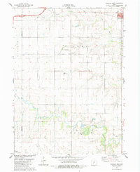
(16)- 1980 Map of Nevinville, 1981 Print
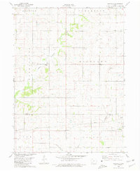 1980 Nevinville1981 Print · USGSAdair and Adams counties in the early eighties are defined by the winding Middle Nodaway River and scattered farmstead communities. Genealogists and local historians can locate Rose Hill Cem, Mormon Cem, and several rural country churches like Penn Avenue Ch.
 - 1980 Map of Bridgewater, 1981 Print
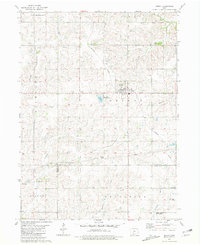
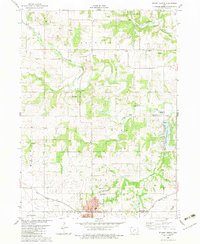
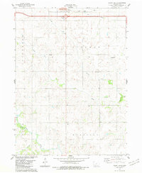
 1980 Bridgewater1981 Print · USGSBridgewater and its surrounding townships are shown here during the late seventies, a period of established rail lines and preserved pioneer history. Genealogists can locate family burial sites like Winn Cem or explore the area around Mormon Trail County Park.
 - 1981 Map of Zion
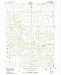
 1981 Zion1981 Print · USGSSouthern Iowa's rural landscape is captured here in the early eighties, showing a network of agricultural townships and family homesteads. Genealogists and historians can trace the local landmarks of Zion, find quiet burial grounds like Wilson Cem, and follow the Burlington Northern rail line.
 - 1981 Map of Orient
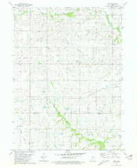
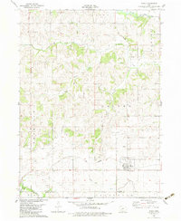
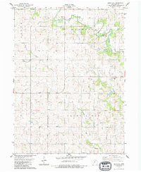
 1981 Orient1981 Print · USGSAdair County farm country is captured here in the early eighties, centered on the railroad hub of Orient. Genealogists and local historians can trace legacy sites like the Prairie Lawn Cemetery or the rural settlements of Nevinville and Spaulding.
 - 1982 Map of Redfield, 1983 Print
 1982 Redfield1983 Print · USGSRedfield and Dexter flourished as rail and river towns in the early 1980s, serving as industrial and agricultural centers for Dallas County. Genealogists and historians can trace local family lineages through several rural burial grounds, including Harper Cem, Spillers Cem, and the historic Bear Creek Ch.
 - 1982 Map of Stuart North, 1983 Print
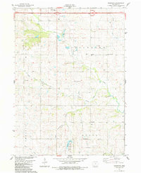
 1982 Stuart North1983 Print · USGSGuthrie and Adair counties come into focus in the early eighties as the rail-and-river economy centers on the town of Stuart. Researchers can trace the path of the Iowa Railroad or locate family plots at Morrisburg Cem and North Oak Grove Cem.
 - 1982 Map of Menlo, 1983 Print
 1982 Menlo1983 Print · USGSGuthrie and Adair counties appear in the early eighties as a landscape of established rail lines and agricultural watersheds. Genealogists and historians can trace the Iowa Railroad through Menlo, locate Rosehill Cem, and follow the Old Railroad Grade near Glendon.
 - 1983 Map of Rosserdale, 1984 Print
 1983 Rosserdale1984 Print · USGSAdair County's rural townships are captured in the early 1980s, showcasing the transition between traditional farming communities and modern infrastructure. Genealogists and local historians can locate several family-centric landmarks including Rosserdale, Jefferson Center Ch, and Grove Center Cem.
 - 1983 Map of Earlham West, 1984 Print
 1983 Earlham West1984 Print · USGSMadison County's agricultural heartland is documented here in the early eighties, just as the modern interstate began to reshape rural travel. Trace family history and local landmarks through sites like Old Penn Center Cem, Early Chapel, and the riverfront quarries.
 - 1983 Map of Stuart South, 1984 Print
 1983 Stuart South1984 Print · USGSAdair County farm country is captured here in the early 1980s, centered on the rural townships south of the Interstate. Genealogists and local historians can locate the Fairview Ch, Mt Vernon Ch, and the small settlement of Townhall.
 - 1983 Map of Pitzer, 1984 Print
 1983 Pitzer1984 Print · USGSMadison County in the early eighties preserves a quiet agricultural landscape shaped by its river bends and timbered draws. Genealogists and historians can locate the Roseman Covered Bridge, family sites like Wintermantle Cem, and the small settlement of Pitzer.
 - 1983 Map of Arbor Hill, 1984 Print
 1983 Arbor Hill1984 Print · USGSAdair County farm country is documented here in the early eighties as a network of quiet townships and winding prairie rivers. Genealogists can trace family landmarks and burial sites like Roberts Cem, the settlement at Hebron, and the rural Bethel Ch.
 - 1983 Map of Greenfield, 1984 Print
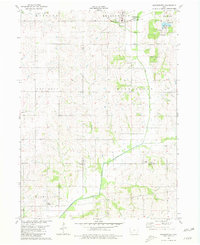
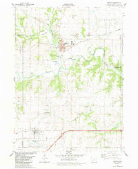
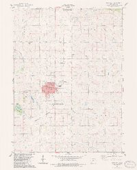 1983 Greenfield1984 Print · USGSGreenfield was a thriving Adair County hub in the early 1980s, balancing its railroad roots with modern civic growth. Researchers can trace local history through the Burlington Northern line, the Greenfield Cemetery, and the Fairground.
 - 1983 Map of Macksburg, 1984 Print
 1983 Macksburg1984 Print · USGSMadison County farmland in the early eighties centers on the village of Macksburg and the meandering Grand River. Researchers can locate family roots at several rural burial grounds, including Kivett Cem, West Branch Cem, and Moon Cem.
 - 1984 Map of Guthrie Center, 1985 Print
 1984 Guthrie Center1985 Print · USGSWest-central Iowa's river valleys and farming townships are shown here in the mid-1980s, highlighting a network of conservation areas and historic rail towns. Genealogists and local historians can locate Violet Hill Cem, trace the Chicago and North Western railroad, or explore the grounds of Springbrook State Park.
 - 1985 Map of Creston
 1985 Creston1985 Print · USGSSouthwest Iowa in the mid-eighties shows a landscape of established farm towns and growing regional hubs connected by vital rail lines. Genealogists and local historians can trace landmarks like Graceland Cem, the Southwestern Community College campus, and the Burlington Northern railroad route.
End of results
Showing maps 1-16 of 16
Top cities of Adair County
- Greenfield historical maps
- Fontanelle historical maps
- Orient historical maps
- Bridgewater historical maps
Frequently asked questions
- What are the different types of historical maps available for Adair County?
- What is the oldest map of Adair County?
- Where can I purchase historical maps of Adair County for my home or office?
- Where can I download high-res historical maps of Adair County?
- Are there historical topographic maps available for Adair County?
- Is there historical aerial imagery available for Adair County?
- Where are historical maps of Adair County sourced from?