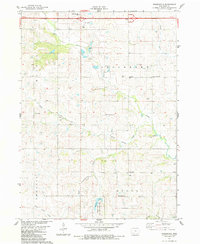
1983 Map of Rosserdale
USGS Topo · Published 1984About this map
The small settlements of Rosserdale and Howe anchor this rural landscape in Adair County during the early 1980s. A network of rural institutions provides a clear picture of local community life, featuring several country churches and burial grounds such as Jefferson Center Ch, Loucks Grove Ch, and the Jefferson Cem. The drainage patterns are defined by the Middle River and North River, while the southern reaches are dominated by the Meadow Lake State Public Hunting Area and Meadow Lake. Transport and industry are represented by the presence of Interstate 80 along the northern border, the Shelley Landing Strip, and multiple extraction sites including a Gravel Pit and several quarries. This survey documents the intersection of modern highway infrastructure with traditional township divisions like Jefferson, Walnut, Prussia, and Grove.
Find a feature on this map
30 named features on this map. Tap any name to fly to it.
Don’t see what you’re looking for? This feature index may not catch every label — zoom into the map to look around manually.
Map Details
Editions of this 1983 Rosserdale Map
This is the sole edition of this map. No revisions or reprints were ever made.
Other maps of this area

1952 · Panora
USGS Topo · 1:62,500

1954 · Greenfield
USGS Topo · 1:62,500

1954 · Omaha
USGS Topo · 1:250,000

1957 · Omaha
USGS Topo · 1:250,000

1958 · Omaha
USGS Topo · 1:250,000

1971 · Fontanelle
USGS Topo · 1:24,000

1971 · Canby
USGS Topo · 1:24,000

1971 · Casey
USGS Topo · 1:24,000
1982 · Stuart North
USGS Topo · 1:24,000
1982 · Menlo
USGS Topo · 1:24,000