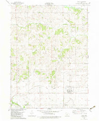
1982 Map of Menlo
USGS Topo · Published 1983About this map
The town of Menlo anchors this Guthrie County landscape, situated at a key intersection of agricultural transport and regional topography in the early 1980s. The town sits along the Iowa Railroad, while just north, an Old Railroad Grade hints at earlier transportation networks that once linked the settlement of Glendon to the wider region. The area is defined by a dense network of watercourses, including the South Raccoon River at the northern edge and the Middle River and North River to the south. Local history is grounded in sites like Rosehill Cem, while the terrain is organized into civil divisions such as Beaver, Thompson, and Walnut. This map details the rural character of the Guthrie and Adair county border before major modern infrastructure changes, preserving the locations of smaller drainage features like Deer Creek and South Branch Beaver Creek.
Find a feature on this map
20 named features on this map. Tap any name to fly to it.
Don’t see what you’re looking for? This feature index may not catch every label — zoom into the map to look around manually.
Map Details
Editions of this 1982 Menlo Map
This is the sole edition of this map. No revisions or reprints were ever made.
Other maps of this area

1952 · Panora
USGS Topo · 1:62,500

1954 · Greenfield
USGS Topo · 1:62,500

1954 · Omaha
USGS Topo · 1:250,000

1957 · Omaha
USGS Topo · 1:250,000

1958 · Omaha
USGS Topo · 1:250,000

1971 · Canby
USGS Topo · 1:24,000

1971 · Casey
USGS Topo · 1:24,000

1971 · Guthrie Center West
USGS Topo · 1:24,000

1982 · Guthrie Center East
USGS Topo · 1:24,000

1982 · Panora
USGS Topo · 1:24,000