
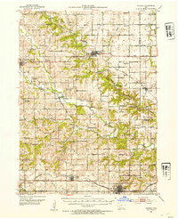
1952 Map of Panora
USGS Topo · Published 1954About this map
The Middle Raccoon River and South Raccoon River carve through Guthrie County, anchoring a landscape defined by small mid-century farming hubs and a dense network of country schools. At this time, regional transport is split between the northern Chicago Milwaukee St Paul and Pacific line passing through Panora and the southern Chicago Rock Island and Pacific route serving Stuart and Menlo. Local history is visible in the transition of rural education, as the map identifies numerous active and shuttered sites like School No 2 (Abandoned) and Frog Pond Sch. The layout of landmarks such as the County Home near Guthrie Center and various burial grounds like Morrisburg Cem provides a clear view of the social and civic infrastructure in central Iowa during the early 1950s.
Find a feature on this map
63 named features on this map. Tap any name to fly to it.
Don’t see what you’re looking for? This feature index may not catch every label — zoom into the map to look around manually.
Map Details
Editions of this 1952 Panora Map
2 editions found
Other maps of this area

1949 · Adel
USGS Topo · 1:62,500

1950 · Perry
USGS Topo · 1:62,500

1951 · Perry
USGS Topo · 1:62,500

1951 · Adel
USGS Topo · 1:62,500

1952 · Winterset
USGS Topo · 1:62,500

1954 · Bagley
USGS Topo · 1:62,500

1954 · Greenfield
USGS Topo · 1:62,500

1954 · Omaha
USGS Topo · 1:250,000

1957 · Omaha
USGS Topo · 1:250,000

1958 · Omaha
USGS Topo · 1:250,000