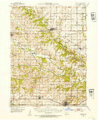
1952 Map of Panora
USGS Topo · Published 1954About this map
The Middle Raccoon River and South Raccoon River carve deep valleys through Guthrie County, shaping a landscape defined by sharp elevation changes and high-ridge farming. In the early 1950s, the area remained a network of rural school districts, many of which had transitioned to other uses, such as School No 2 (Abandoned) and School No 9 (Abandoned). The topography dictated the paths of the major rail lines, with the Chicago Milwaukee St Paul and Pacific serving the north and the Chicago Rock Island and Pacific running through Menlo and Stuart in the south.
Find a feature on this map
62 named features on this map. Tap any name to fly to it.
Don’t see what you’re looking for? This feature index may not catch every label — zoom into the map to look around manually.
Map Details
Editions of this 1952 Panora Map
2 editions found
Other maps of this area

1949 · Adel
USGS Topo · 1:62,500

1950 · Perry
USGS Topo · 1:62,500

1951 · Perry
USGS Topo · 1:62,500

1951 · Adel
USGS Topo · 1:62,500

1952 · Panora
USGS Topo · 1:62,500

1952 · Winterset
USGS Topo · 1:62,500

1954 · Bagley
USGS Topo · 1:62,500

1954 · Greenfield
USGS Topo · 1:62,500

1954 · Omaha
USGS Topo · 1:250,000

1957 · Omaha
USGS Topo · 1:250,000