
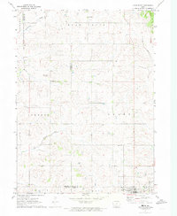
1971 Map of Casey
USGS Topo · Published 1973About this map
Casey sits at the southern edge of this Iowa landscape, positioned where the Chicago Rock Island and Pacific Railroad cuts across the border between Guthrie and Adair Counties. The area is defined by the branching waterways of the Middle River system, including the South Fork and Beaver Creek. To the north, the small Dalmanutha Cemetery remains a quiet landmark within Thompson township, reflecting the earlier rural burial grounds established as the region was settled into a grid of townships like Baker and Grant. The presence of the Adair-Casey High School near the southern boundary highlights the consolidation of local rural communities in the mid-20th century. This survey preserves the exact alignment of section roads and water crossings before modern infrastructure expansion altered the local agricultural patterns.
Find a feature on this map
14 named features on this map. Tap any name to fly to it.
Don’t see what you’re looking for? This feature index may not catch every label — zoom into the map to look around manually.
Map Details
Editions of this 1971 Casey Map
This is the sole edition of this map. No revisions or reprints were ever made.
Other maps of this area

1952 · Panora
USGS Topo · 1:62,500

1954 · Greenfield
USGS Topo · 1:62,500

1954 · Omaha
USGS Topo · 1:250,000

1957 · Omaha
USGS Topo · 1:250,000

1958 · Omaha
USGS Topo · 1:250,000

1971 · Adair South
USGS Topo · 1:24,000

1971 · Canby
USGS Topo · 1:24,000

1971 · North Branch
USGS Topo · 1:24,000

1971 · Guthrie Center West
USGS Topo · 1:24,000
1971 · Adair North
USGS Topo · 1:24,000