1970s Maps of Audubon County, Iowa
Explore 8 historic maps of Audubon County from the 1970s. These maps offer a rare glimpse into what life looked like during the 1970s — showing old roads, neighborhoods, homes, and landmarks that have changed or disappeared over time.
Whether you're researching your family's past, planning a metal detecting trip, or studying how Audubon County's landscape evolved across the 1970s, these high-resolution maps are a powerful tool for exploring the history of this region.
- Focus on a specific era: All maps on this page are from the 1970s, giving you a focused view of this time period.
- See what’s changed: Compare century-old streets, trails, and buildings to today's modern landscape using overlays and satellite layers.
- Research with precision: Use these maps for genealogy, historical research, land use analysis, or educational projects.
- View, download, or print: Maps are fully viewable online in high resolution, and can be downloaded or printed for your own records.
Start exploring Audubon County's history through authentic maps from the 1970s. This is your window into the past.
Audubon County, IA maps
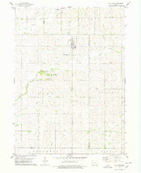
(8)- 1971 Map of Coon Rapids South, 1973 Print
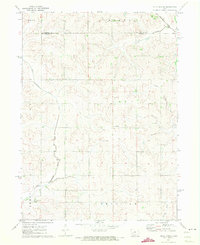
 1971 Coon Rapids South1973 Print · USGSGuthrie and Carroll counties come together in the early seventies as the rail-and-river economy centers on Coon Rapids. Researchers can trace old family plots at Tuttles Grove Cem or locate the rural Townhall near the banks of Brushy Creek.
 - 1971 Map of Viola Center, 1973 Print
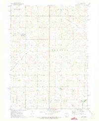
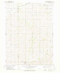
 1971 Viola Center1973 Print · USGSThe rural borders of Audubon and Carroll counties are captured here in the early 1970s, showcasing a landscape of section-line roads and winding river valleys. Local historians can locate the Viola Center Cem and trace the course of the East Nishnabotna River.
 - 1971 Map of North Branch, 1973 Print
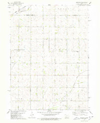
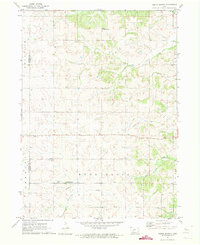 1971 North Branch1973 Print · USGSGuthrie County and Audubon County are captured here in the early 1970s as agricultural life centered around small township hubs. Genealogists and local historians can trace the locations of Bowman Chapel, Township Cem, and the settlement of North Branch.
 - 1971 Map of Gray, 1973 Print
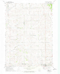
 1971 Gray1973 Print · USGSThe rural landscape of Audubon and Carroll counties is captured here in the early seventies, centered on the small communities of Gray and Ross. Genealogists and researchers can locate family plots at Gray Cem or Cameron Cem and trace the forks of the East Nishnabotna River.
 - 1971 Map of Adair North, 1973 Print
 1971 Adair North1973 Print · USGSGuthrie, Audubon, and Adair counties converge in this early 1970s landscape of rolling prairie and winding creek beds. Researchers can locate specific rural landmarks like St Johns Church and Kenfield, or trace the path of the Old RR Grade.
 - 1978 Map of Elk Horn
 1978 Elk Horn1978 Print · USGSThe Danish settlements of the Iowa plains are captured here in the late seventies as established rural communities. Genealogists can trace family roots through sites like Carlsen-Larsen Cem or explore the drainage of Elkhorn Creek and Buck Creek.
 - 1978 Map of Kimballton
 1978 Kimballton1978 Print · USGSThe borderlands of Audubon and Shelby Counties are captured here in the late seventies, showing a landscape of productive farms and small rural centers. Researchers can trace family roots at Ebenezer Cem or locate the historic sites of Poplar, Fiscus, and Kimballton.
 - 1978 Map of Manning SE
 1978 Manning SE1978 Print · USGSWestern Iowa's agricultural heartland is documented here in the late seventies, where four counties converge at the headwaters of the Nishnabotna system. Genealogists and local historians can locate rural landmarks like Trinity Ch, the Township Cem, and the path of the Chicago and North Western railroad.
End of results
Showing maps 1-8 of 8
Top cities of Audubon County
- Audubon historical maps
- Exira historical maps
- Kimballton historical maps
- Brayton historical maps
- Gray historical maps
Frequently asked questions
- What are the different types of historical maps available for Audubon County?
- What is the oldest map of Audubon County?
- Where can I purchase historical maps of Audubon County for my home or office?
- Where can I download high-res historical maps of Audubon County?
- Are there historical topographic maps available for Audubon County?
- Is there historical aerial imagery available for Audubon County?
- Where are historical maps of Audubon County sourced from?