1980s Maps of Audubon County, Iowa
Explore 6 historic maps of Audubon County from the 1980s. These maps offer a rare glimpse into what life looked like during the 1980s — showing old roads, neighborhoods, homes, and landmarks that have changed or disappeared over time.
Whether you're researching your family's past, planning a metal detecting trip, or studying how Audubon County's landscape evolved across the 1980s, these high-resolution maps are a powerful tool for exploring the history of this region.
- Focus on a specific era: All maps on this page are from the 1980s, giving you a focused view of this time period.
- See what’s changed: Compare century-old streets, trails, and buildings to today's modern landscape using overlays and satellite layers.
- Research with precision: Use these maps for genealogy, historical research, land use analysis, or educational projects.
- View, download, or print: Maps are fully viewable online in high resolution, and can be downloaded or printed for your own records.
Start exploring Audubon County's history through authentic maps from the 1980s. This is your window into the past.
Audubon County, IA maps
(6)- 1980 Map of Harlan
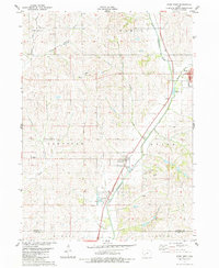
 1980 Harlan1980 Print · USGSWestern Iowa and the Nebraska borderlands are shown in the early eighties as a vital corridor of rail and river commerce. Genealogists and local historians can trace family roots through old rural crossroads like Beebeetown and Westphalia, or locate landmarks like Rose Hill Cem.
 - 1983 Map of Exira West, 1984 Print
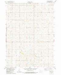
 1983 Exira West1984 Print · USGSThe East Nishnabotna River valley in the early 1980s reveals a classic Iowa landscape of river-side towns and rural townships. Researchers can find well-preserved details of Exira, Brayton, and several country cemeteries like St Johns Cem and Oakfield Cem.
 - 1983 Map of Exira East, 1984 Print
 1983 Exira East1984 Print · USGSThe town of Exira and its surrounding townships are shown here in the early 1980s, capturing the structured rural layout of Audubon County. Researchers can trace family history through several local landmarks, including Holy Trinity Cem, Grove Cem, and Littlefield County Park.
 - 1983 Map of Gardner, 1984 Print
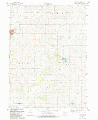
 1983 Gardner1984 Print · USGSAudubon County’s rural townships are shown here in the early eighties as a strictly ordered grid of family farms and creek valleys. Genealogists can locate family holdings near Gardner and Larland, or find records at the Township Cem along the drainage of Honey Creek.
 - 1983 Map of Audubon, 1984 Print
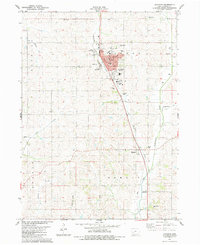 1983 Audubon1984 Print · USGSAudubon and the surrounding prairie townships are captured here in the early eighties as the community balanced its civic core with its river-valley agriculture. You can trace the locations of family burial grounds at Aretas Lodge Cemetery and Danish Cemetery, or locate the Courthouse and County Fairgrounds.
 - 1984 Map of Guthrie Center, 1985 Print
 1984 Guthrie Center1985 Print · USGSWest-central Iowa's river valleys and farming townships are shown here in the mid-1980s, highlighting a network of conservation areas and historic rail towns. Genealogists and local historians can locate Violet Hill Cem, trace the Chicago and North Western railroad, or explore the grounds of Springbrook State Park.
End of results
Showing maps 1-6 of 6
Top cities of Audubon County
- Audubon historical maps
- Exira historical maps
- Kimballton historical maps
- Brayton historical maps
- Gray historical maps
Frequently asked questions
- What are the different types of historical maps available for Audubon County?
- What is the oldest map of Audubon County?
- Where can I purchase historical maps of Audubon County for my home or office?
- Where can I download high-res historical maps of Audubon County?
- Are there historical topographic maps available for Audubon County?
- Is there historical aerial imagery available for Audubon County?
- Where are historical maps of Audubon County sourced from?