1930s Maps of Carlisle, Iowa
Explore 2 historic maps of Carlisle from the 1930s. These maps offer a rare glimpse into what life looked like during the 1930s — showing old roads, neighborhoods, homes, and landmarks that have changed or disappeared over time.
Whether you're researching your family's past, planning a metal detecting trip, or studying how Carlisle's landscape evolved across the 1930s, these high-resolution maps are a powerful tool for exploring the history of this region.
- Focus on a specific era: All maps on this page are from the 1930s, giving you a focused view of this time period.
- See what’s changed: Compare century-old streets, trails, and buildings to today's modern landscape using overlays and satellite layers.
- Research with precision: Use these maps for genealogy, historical research, land use analysis, or educational projects.
- View, download, or print: Maps are fully viewable online in high resolution, and can be downloaded or printed for your own records.
Start exploring Carlisle's history through authentic maps from the 1930s. This is your window into the past.
Carlisle, IA maps
(2)- 1930 Map of Mitchellville
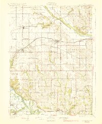 1930 Mitchellville1930 Print · USGSCentral Iowa's fertile prairie and river valleys come alive in this late 1920s survey of the settlements between the Skunk and Des Moines rivers. Researchers can locate dozens of country schools like Nebo Sch and Peacock Sch or trace family roots near Camp Center Ch.3 unique versions available
 - 1931 Map of Indianola
 1931 Indianola1931 Print · USGSWarren County at the end of the 1920s reveals a landscape of thriving rail junctions and rural schoolhouses across central Iowa. Researchers can trace the path of the Chicago Great Western RR through Martensdale and locate local landmarks like Scotch Ridge Sch and the Orillia Mine.4 unique versions available
End of results
Showing maps 1-2 of 2
Top cities near Carlisle
- Des Moines historical maps
- West Des Moines historical maps
- Ankeny historical maps
- Urbandale historical maps
- Johnston historical maps
- Altoona historical maps
See more
Frequently asked questions
- What are the different types of historical maps available for Carlisle?
- What is the oldest map of Carlisle?
- Where can I purchase historical maps of Carlisle for my home or office?
- Where can I download high-res historical maps of Carlisle?
- Are there historical topographic maps available for Carlisle?
- Is there historical aerial imagery available for Carlisle?
- Where are historical maps of Carlisle sourced from?