1970s Maps of Carlisle, Iowa
Explore 2 historic maps of Carlisle from the 1970s. These maps offer a rare glimpse into what life looked like during the 1970s — showing old roads, neighborhoods, homes, and landmarks that have changed or disappeared over time.
Whether you're researching your family's past, planning a metal detecting trip, or studying how Carlisle's landscape evolved across the 1970s, these high-resolution maps are a powerful tool for exploring the history of this region.
- Focus on a specific era: All maps on this page are from the 1970s, giving you a focused view of this time period.
- See what’s changed: Compare century-old streets, trails, and buildings to today's modern landscape using overlays and satellite layers.
- Research with precision: Use these maps for genealogy, historical research, land use analysis, or educational projects.
- View, download, or print: Maps are fully viewable online in high resolution, and can be downloaded or printed for your own records.
Start exploring Carlisle's history through authentic maps from the 1970s. This is your window into the past.
Carlisle, IA maps
(2)- 1972 Map of Scotch Ridge, 1974 Print
 1972 Scotch Ridge1974 Print · USGSWarren County terrain in the early seventies shows a landscape shaped by the Middle River and the regional rail network. Genealogists and local historians can locate the Laverty Cem, North River Ch, and the community of Summerset along the railroad line.
 - 1972 Map of Rising Sun, 1974 Print
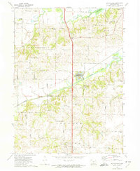
 1972 Rising Sun1974 Print · USGSSoutheast of Des Moines in the early seventies, the river landscape around Carlisle and Rising Sun shows a blend of rural township life and growing suburban tracts. Researchers can trace the heritage of local families at Powers-Warren Cem and locate old rail corridors like the Chicago Rock Island and Pacific Railroad.
End of results
Showing maps 1-2 of 2
Top cities near Carlisle
- Des Moines historical maps
- West Des Moines historical maps
- Ankeny historical maps
- Urbandale historical maps
- Johnston historical maps
- Altoona historical maps
See more
Frequently asked questions
- What are the different types of historical maps available for Carlisle?
- What is the oldest map of Carlisle?
- Where can I purchase historical maps of Carlisle for my home or office?
- Where can I download high-res historical maps of Carlisle?
- Are there historical topographic maps available for Carlisle?
- Is there historical aerial imagery available for Carlisle?
- Where are historical maps of Carlisle sourced from?