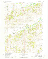
1972 Map of Scotch Ridge
USGS Topo · Published 1974About this map
Scotch Ridge rises between the valleys of the North River and the Middle River in this detailed topographic survey of Warren County. The landscape is defined by the convergence of these waterways, which wind through the townships of Greenfield, Allen, Lincoln, and Washington. The Chicago Rock Island and Pacific Railroad cuts a north-south path through the center of the sheet, connecting the small community of Summerset to the northern settlement of Carlisle.
Find a feature on this map
50 named features on this map. Tap any name to fly to it.
Don’t see what you’re looking for? This feature index may not catch every label — zoom into the map to look around manually.
Map Details
Editions of this 1972 Scotch Ridge Map
This is the sole edition of this map. No revisions or reprints were ever made.
Other maps of this area

1905 · Des Moines
USGS Topo · 1:62,500

1907 · Des Moines
USGS Topo · 1:62,500

1910 · Milo
USGS Topo · 1:62,500

1930 · Mitchellville
USGS Topo · 1:62,500

1931 · Indianola
USGS Topo · 1:62,500

1954 · Des Moines
USGS Topo · 1:250,000

1956 · Des Moines
USGS Topo · 1:250,000

1956 · Des Moines SW
USGS Topo · 1:24,000

1956 · Des Moines SE
USGS Topo · 1:24,000

1956 · Des Moines
USGS Topo · 1:62,500