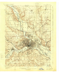
1956 Map of Des Moines
USGS Topo · Published 1959About this map
The confluence of the Des Moines River and Raccoon River anchors this 1950s portrait of Iowa's capital and its surrounding townships. Post-war expansion is evident in the burgeoning residential grids of Urbandale, Windsor Heights, and West Des Moines, while the city core remains defined by institutional landmarks such as the State Capitol and Drake University. The map documents a dense network of educational and religious infrastructure, featuring dozens of sites like Dowling High Sch, All Saints Sch, and Sacred Heart Sch.
Find a feature on this map
136 named features on this map. Tap any name to fly to it.
Don’t see what you’re looking for? This feature index may not catch every label — zoom into the map to look around manually.
Map Details
Editions of this 1956 Des Moines Map
This is the sole edition of this map. No revisions or reprints were ever made.
Historical Maps of Des Moines Through Time
8 maps found