1960s Maps of Clay County, Iowa
Explore 4 historic maps of Clay County from the 1960s. These maps offer a rare glimpse into what life looked like during the 1960s — showing old roads, neighborhoods, homes, and landmarks that have changed or disappeared over time.
Whether you're researching your family's past, planning a metal detecting trip, or studying how Clay County's landscape evolved across the 1960s, these high-resolution maps are a powerful tool for exploring the history of this region.
- Focus on a specific era: All maps on this page are from the 1960s, giving you a focused view of this time period.
- See what’s changed: Compare century-old streets, trails, and buildings to today's modern landscape using overlays and satellite layers.
- Research with precision: Use these maps for genealogy, historical research, land use analysis, or educational projects.
- View, download, or print: Maps are fully viewable online in high resolution, and can be downloaded or printed for your own records.
Start exploring Clay County's history through authentic maps from the 1960s. This is your window into the past.
Clay County, IA maps
(4)- 1966 Map of Spencer, 1967 Print
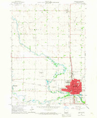 1966 Spencer1967 Print · USGSSpencer and the surrounding Clay County prairies thrived as a rail and river hub in the mid-1960s. Genealogists and local historians can trace legacy sites like Riverside Cemetery, local schools such as North School, and landmarks including the County Fairground.2 unique versions available
 - 1966 Map of Gillett Grove, 1967 Print
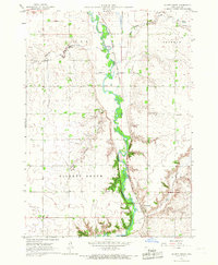 1966 Gillett Grove1967 Print · USGSClay County's rural landscape is captured here in the mid-1960s as the river-and-rail economy centered on Gillett Grove remained in full swing. Researchers can trace the Chicago Milwaukee St Paul and Pacific railroad line or find the Rose Hill Cem.
 - 1966 Map of Greenville, 1967 Print
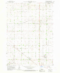 1966 Greenville1967 Print · USGSClay County's rural landscape is captured here in the mid-sixties, dominated by the diagonal path of the Chicago Rock Island and Pacific railroad. Genealogists can locate family sites at Lincoln Cem and Lutheran Cem or trace the early plats of Rossie and Greenville.
 - 1966 Map of Dickens, 1967 Print
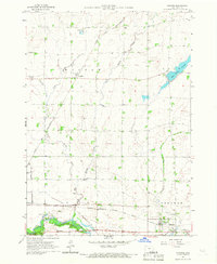 1966 Dickens1967 Print · USGSClay County's rural townships and rail corridors are preserved here as they appeared in the mid-1960s. Genealogists and local historians can trace the foundations of Dickens and Langdon or locate landmarks like Fairview Cem and Kingdom Hall.
End of results
Showing maps 1-4 of 4
Top cities of Clay County
- Spencer historical maps
- Everly historical maps
- Royal historical maps
- Peterson historical maps
- Fostoria historical maps
- Dickens historical maps
See more
Frequently asked questions
- What are the different types of historical maps available for Clay County?
- What is the oldest map of Clay County?
- Where can I purchase historical maps of Clay County for my home or office?
- Where can I download high-res historical maps of Clay County?
- Are there historical topographic maps available for Clay County?
- Is there historical aerial imagery available for Clay County?
- Where are historical maps of Clay County sourced from?