1980s Maps of Lamoni, Iowa
Explore 3 historic maps of Lamoni from the 1980s. These maps offer a rare glimpse into what life looked like during the 1980s — showing old roads, neighborhoods, homes, and landmarks that have changed or disappeared over time.
Whether you're researching your family's past, planning a metal detecting trip, or studying how Lamoni's landscape evolved across the 1980s, these high-resolution maps are a powerful tool for exploring the history of this region.
- Focus on a specific era: All maps on this page are from the 1980s, giving you a focused view of this time period.
- See what’s changed: Compare century-old streets, trails, and buildings to today's modern landscape using overlays and satellite layers.
- Research with precision: Use these maps for genealogy, historical research, land use analysis, or educational projects.
- View, download, or print: Maps are fully viewable online in high resolution, and can be downloaded or printed for your own records.
Start exploring Lamoni's history through authentic maps from the 1980s. This is your window into the past.
Lamoni, IA maps
(3)- 1981 Map of Lamoni South
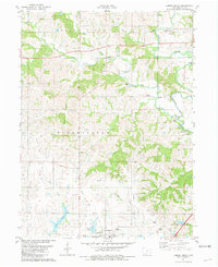
 1981 Lamoni South1981 Print · USGSSouthern Iowa and northern Missouri are captured here in the early eighties, centered on the growing community of Lamoni. Genealogists and local historians can trace rural roots through Rose Hill Cem, Sweet Home Cem, and the old Andover townsite.2 unique versions available
 - 1981 Map of Lamoni North
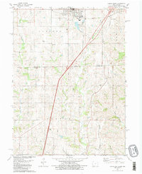
 1981 Lamoni North1981 Print · USGSDecatur County's rural heartland is documented here in the early eighties, centered on the expansion of Lamoni and the river valleys to its north. Genealogists can locate family landmarks such as Rose Hill Cem, the Bloomington Ch, and the Old Railroad Grade.
 - 1981 Map of Leon, 1982 Print
 1981 Leon1982 Print · USGSSouthern Iowa and northern Missouri are captured here in the early eighties as the rural landscape balances traditional agriculture with large-scale water management. Researchers can trace the path of the Burlington Northern through Leon or locate early settlements like Decatur City and New Buda.
End of results
Showing maps 1-3 of 3
Top cities near Lamoni
- Leon historical maps
- Cainsville historical maps
- Eagleville historical maps
- Kellerton historical maps
- Blythedale historical maps
- Grand River historical maps
See more
Frequently asked questions
- What are the different types of historical maps available for Lamoni?
- What is the oldest map of Lamoni?
- Where can I purchase historical maps of Lamoni for my home or office?
- Where can I download high-res historical maps of Lamoni?
- Are there historical topographic maps available for Lamoni?
- Is there historical aerial imagery available for Lamoni?
- Where are historical maps of Lamoni sourced from?