1970s Maps of Hampton, Iowa
Explore 2 historic maps of Hampton from the 1970s. These maps offer a rare glimpse into what life looked like during the 1970s — showing old roads, neighborhoods, homes, and landmarks that have changed or disappeared over time.
Whether you're researching your family's past, planning a metal detecting trip, or studying how Hampton's landscape evolved across the 1970s, these high-resolution maps are a powerful tool for exploring the history of this region.
- Focus on a specific era: All maps on this page are from the 1970s, giving you a focused view of this time period.
- See what’s changed: Compare century-old streets, trails, and buildings to today's modern landscape using overlays and satellite layers.
- Research with precision: Use these maps for genealogy, historical research, land use analysis, or educational projects.
- View, download, or print: Maps are fully viewable online in high resolution, and can be downloaded or printed for your own records.
Start exploring Hampton's history through authentic maps from the 1970s. This is your window into the past.
Hampton, IA maps
(2)- 1972 Map of Hampton North, 1975 Print
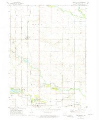 1972 Hampton North1975 Print · USGSFranklin County's agricultural and rail heritage is well-preserved in this early 1970s landscape where the towns of Hampton and Chapin meet. Genealogists and historians can trace the Chicago Rock Island and Pacific tracks and locate the Way Side Cem or the State Fish Hatchery.
 - 1979 Map of Hampton South, 1980 Print
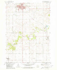 1979 Hampton South1980 Print · USGSFranklin County's agricultural heartland is documented here in the late seventies, centered on the hub of Hampton. Genealogists and historians can trace several rural burial grounds like Redding Cem and find school sites such as the Geneva Ackley Sch.
End of results
Showing maps 1-2 of 2
Top cities near Hampton
- Iowa Falls historical maps
- Ackley historical maps
- Sheffield historical maps
- Alden historical maps
- Dumont historical maps
- Latimer historical maps
See more
Frequently asked questions
- What are the different types of historical maps available for Hampton?
- What is the oldest map of Hampton?
- Where can I purchase historical maps of Hampton for my home or office?
- Where can I download high-res historical maps of Hampton?
- Are there historical topographic maps available for Hampton?
- Is there historical aerial imagery available for Hampton?
- Where are historical maps of Hampton sourced from?