1980s Maps of Grundy County, Iowa
Explore 8 historic maps of Grundy County from the 1980s. These maps offer a rare glimpse into what life looked like during the 1980s — showing old roads, neighborhoods, homes, and landmarks that have changed or disappeared over time.
Whether you're researching your family's past, planning a metal detecting trip, or studying how Grundy County's landscape evolved across the 1980s, these high-resolution maps are a powerful tool for exploring the history of this region.
- Focus on a specific era: All maps on this page are from the 1980s, giving you a focused view of this time period.
- See what’s changed: Compare century-old streets, trails, and buildings to today's modern landscape using overlays and satellite layers.
- Research with precision: Use these maps for genealogy, historical research, land use analysis, or educational projects.
- View, download, or print: Maps are fully viewable online in high resolution, and can be downloaded or printed for your own records.
Start exploring Grundy County's history through authentic maps from the 1980s. This is your window into the past.
Grundy County, IA maps
(8)- 1980 Map of Aplington
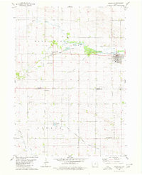 1980 Aplington1980 Print · USGSThe Butler and Grundy county line comes alive in this 1980s-era survey, where the Illinois Central Gulf railroad links the towns of Aplington and Austinville. Trace family history through landmarks like Westfriesland Ch and Excelsior Sch.
 - 1980 Map of Wellsburg
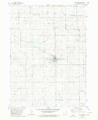 1980 Wellsburg1980 Print · USGSGrundy County farmland and the railroad town of Wellsburg are captured here during the 1980s. Genealogists and local historians can locate family landmarks such as Timothy Sch, St Pauls Ch, and the Shiloh Cem.
 - 1980 Map of Ivester
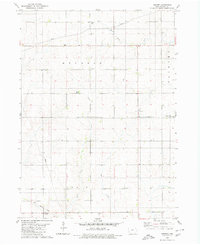 1980 Ivester1980 Print · USGSGrundy County farmland in the 1970s is meticulously captured here, showing the rural settlement patterns and local townships. Researchers can locate family burial sites at Sheller Cem and Alice Union Cem or trace the path of the Old Railroad Grade.
 - 1980 Map of Parkersburg
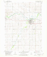 1980 Parkersburg1980 Print · USGSButler County and Grundy County agricultural life is captured here in the late twentieth century, centered on the rail junction at Parkersburg. Researchers can trace old family plots at Oak Hill Cem or locate the rural Salem Ch and Buck Grove settlement.
 - 1984 Map of Marshalltown, 1985 Print
 1984 Marshalltown1985 Print · USGSMid-Iowa's agricultural landscape and river corridors come alive in the mid-eighties as the Cedar River connects industrial hubs and small farm towns. Trace the tracks of the CHICAGO AND NORTHWESTERN or locate local landmarks like Union Grove State Park and Cedar Falls Junction.2 unique versions available
 - 1984 Map of Waverly, 1985 Print
 1984 Waverly1985 Print · USGSNortheast Iowa in the mid-eighties shows a robust network of river towns and rail corridors connecting agricultural centers. Researchers can trace family sites near Garden of Memories Cem or follow the Chicago and North Western line through Janesville and Waverly.2 unique versions available
 - 1984 Map of Iowa Falls, 1985 Print
 1984 Iowa Falls1985 Print · USGSNorth-central Iowa is documented here during the mid-eighties, showing a landscape of traditional rail towns and extensive wildlife management areas. Researchers can trace family history through settlements like Belmond, Dows, and Ackley, or locate landmarks like Beeds Lake State Park.2 unique versions available
 - 1985 Map of Ames
 1985 Ames1985 Print · USGSCentral Iowa's prairie landscape in the mid-eighties shows a well-established network of rail towns and conservation areas. Genealogists and historians can trace the paths of the Lincoln Highway and the Chicago and North Western line connecting Ames, Boone, and Webster City.
End of results
Showing maps 1-8 of 8
Top cities of Grundy County
- Grundy Center historical maps
- Reinbeck historical maps
- Dike historical maps
- Conrad historical maps
- Wellsburg historical maps
- Holland historical maps
See more
Frequently asked questions
- What are the different types of historical maps available for Grundy County?
- What is the oldest map of Grundy County?
- Where can I purchase historical maps of Grundy County for my home or office?
- Where can I download high-res historical maps of Grundy County?
- Are there historical topographic maps available for Grundy County?
- Is there historical aerial imagery available for Grundy County?
- Where are historical maps of Grundy County sourced from?