1980s Maps of Humboldt County, Iowa
Explore 6 historic maps of Humboldt County from the 1980s. These maps offer a rare glimpse into what life looked like during the 1980s — showing old roads, neighborhoods, homes, and landmarks that have changed or disappeared over time.
Whether you're researching your family's past, planning a metal detecting trip, or studying how Humboldt County's landscape evolved across the 1980s, these high-resolution maps are a powerful tool for exploring the history of this region.
- Focus on a specific era: All maps on this page are from the 1980s, giving you a focused view of this time period.
- See what’s changed: Compare century-old streets, trails, and buildings to today's modern landscape using overlays and satellite layers.
- Research with precision: Use these maps for genealogy, historical research, land use analysis, or educational projects.
- View, download, or print: Maps are fully viewable online in high resolution, and can be downloaded or printed for your own records.
Start exploring Humboldt County's history through authentic maps from the 1980s. This is your window into the past.
Humboldt County, IA maps
(6)- 1980 Map of West Bend, 1981 Print
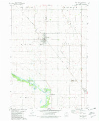 1980 West Bend1981 Print · USGSWest Bend and its surrounding farmsteads are shown during the early 1980s at the junction of four Iowa counties. Researchers can trace the Chicago Rock Island and Pacific rail line between West Bend and Ottosen or locate family sites near McKnights Point and Union Cem.
 - 1980 Map of Bode, 1981 Print
 1980 Bode1981 Print · USGSHumboldt County farmland and river bends are captured here in the late twentieth century as the rail and agricultural networks remained central to local life. Genealogists and historians can trace family roots at St Olaf Cem or explore the river-side industries near Rutland including a local Quarry.
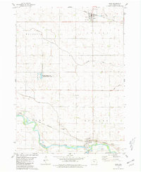
 - 1980 Map of Bradgate, 1981 Print
 1980 Bradgate1981 Print · USGSHumboldt and Pocahontas Counties are shown in the late twentieth century as the rail-and-river landscape centered on Bradgate remained active. Researchers can trace the path of the Chicago and North Western and locate early burial sites like McKnight Cem and Old Rolfe Cem.
 - 1980 Map of West Bend NE, 1981 Print
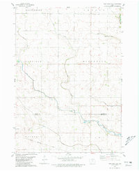 1980 West Bend NE1981 Print · USGSNorth-central Iowa farmland is captured here in the early eighties, showing the transition between Kossuth and Humboldt counties. Genealogists and rail historians can trace the Chicago Rock Island and Pacific line through Ottosen and find local landmarks like the Townhall in Riverdale.
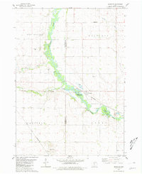
 - 1984 Map of Humboldt, 1985 Print
 1984 Humboldt1985 Print · USGSNorth Central Iowa in the mid-eighties shows a deeply integrated landscape of agricultural drainage and rail-connected settlements. Trace the rural layout of the era via the Chicago and North Western line, Rush Lake, and Lizard Lake County Park.2 unique versions available
 - 1984 Map of Iowa Falls, 1985 Print
 1984 Iowa Falls1985 Print · USGSNorth-central Iowa is documented here during the mid-eighties, showing a landscape of traditional rail towns and extensive wildlife management areas. Researchers can trace family history through settlements like Belmond, Dows, and Ackley, or locate landmarks like Beeds Lake State Park.2 unique versions available
End of results
Showing maps 1-6 of 6
Top cities of Humboldt County
- Humboldt historical maps
- Dakota City historical maps
- Livermore historical maps
- Bode historical maps
- Renwick historical maps
- Thor historical maps
See more
Frequently asked questions
- What are the different types of historical maps available for Humboldt County?
- What is the oldest map of Humboldt County?
- Where can I purchase historical maps of Humboldt County for my home or office?
- Where can I download high-res historical maps of Humboldt County?
- Are there historical topographic maps available for Humboldt County?
- Is there historical aerial imagery available for Humboldt County?
- Where are historical maps of Humboldt County sourced from?