1800s (19th Century) Maps of Jones County, Iowa
Explore 9 historic maps of Jones County from the 1800s (19th Century). These maps offer a rare glimpse into what life looked like during the 1800s — showing old roads, neighborhoods, homes, and landmarks that have changed or disappeared over time.
Whether you're researching your family's past, planning a metal detecting trip, or studying how Jones County's landscape evolved across the 1800s, these high-resolution maps are a powerful tool for exploring the history of this region.
- Focus on a specific era: All maps on this page are from the 1800s, giving you a focused view of this time period.
- See what’s changed: Compare century-old streets, trails, and buildings to today's modern landscape using overlays and satellite layers.
- Research with precision: Use these maps for genealogy, historical research, land use analysis, or educational projects.
- View, download, or print: Maps are fully viewable online in high resolution, and can be downloaded or printed for your own records.
Start exploring Jones County's history through authentic maps from the 1800s. This is your window into the past.
Jones County, IA maps
(9)- 1889 Map of Tipton
 1889 Tipton1889 Print · USGSCedar County at the close of the nineteenth century was a landscape shaped by two major rail lines. Genealogists and local historians can trace the early town plats of Tipton, Mechanicsville, and Stanwood, alongside landmarks like Sugar Creek and the Chicago and North-Western Railroad.
 - 1890 Map of Tipton
 1890 Tipton1890 Print · USGSCedar County in the late nineteenth century is captured here as a thriving rail-centered landscape. Genealogists and local historians can trace the early grids of Tipton, Mechanicsville, and Stanwood along the tracks of the Chicago and North-Western Railroad.2 unique versions available
 - 1890 Map of Anamosa
 1890 Anamosa1890 Print · USGSEastern Iowa was a landscape defined by river valleys and expanding rail lines in the 1890s. Genealogists can trace family roots through early settlements like Anamosa, Springville, and Viola along the Chicago Milwaukee and St. Paul Railroad.2 unique versions available
 - 1891 Map of Monticello
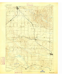 1891 Monticello1891 Print · USGSJones County at the peak of the rail era shows a landscape organized by iron rails and river bends. Trace the junctions and early plats of Monticello, Center Junction, and Wyoming along the Chicago and North Western Railroad.3 unique versions available
 - 1891 Map of Mechanicsville
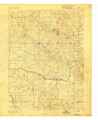
 1891 Mechanicsville1891 Print · USGSEastern Iowa during the late Victorian era is defined here by its emerging rail corridors and the winding path of the Cedar River. Genealogists can trace the early footprints of settlements like Mechanicsville, Mt. Vernon, and Solon before modern development.
 - 1891 Map of Baldwin
 1891 Baldwin1891 Print · USGSJackson County at the end of the century shows a rugged landscape transitioning from river-based industry to a railroad economy. Genealogists can trace family footprints in early settlements like Ozark, Clay Mills, and the rail hubs of Baldwin and Monmouth.3 unique versions available
 - 1892 Map of Wheatland
 1892 Wheatland1892 Print · USGSEastern Iowa in the late nineteenth century was a landscape of burgeoning rail towns and river settlements. Genealogists and historians can trace early property boundaries and rail corridors through Wheatland, the winding Wapsipinicon River, and the curiously named Lost Nation.
 - 1894 Map of Wheatland
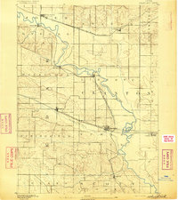
 1894 Wheatland1894 Print · USGSClinton and Jones counties thrived along the river and rail corridors of the 1890s. Genealogists can trace the early development of Oxford Junction and Wheatland, or locate old mill sites near Oxford Mills and Massillon.2 unique versions available
 - 1894 Map of Mechanicsville
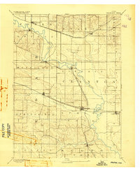
 1894 Mechanicsville1894 Print · USGSEast-central Iowa thrived as a rail and river hub in the 1890s, where major lines connected growing agricultural towns. Researchers can trace the development of Mt. Vernon and Lisbon along the northern tracks or follow the Cedar River to Cedar Bluffs.2 unique versions available
End of results
Showing maps 1-9 of 9
Top cities of Jones County
- Anamosa historical maps
- Monticello historical maps
- Olin historical maps
- Wyoming historical maps
- Oxford Junction historical maps
- Martelle historical maps
See more
Frequently asked questions
- What are the different types of historical maps available for Jones County?
- What is the oldest map of Jones County?
- Where can I purchase historical maps of Jones County for my home or office?
- Where can I download high-res historical maps of Jones County?
- Are there historical topographic maps available for Jones County?
- Is there historical aerial imagery available for Jones County?
- Where are historical maps of Jones County sourced from?