1980s Maps of Jones County, Iowa
Explore 12 historic maps of Jones County from the 1980s. These maps offer a rare glimpse into what life looked like during the 1980s — showing old roads, neighborhoods, homes, and landmarks that have changed or disappeared over time.
Whether you're researching your family's past, planning a metal detecting trip, or studying how Jones County's landscape evolved across the 1980s, these high-resolution maps are a powerful tool for exploring the history of this region.
- Focus on a specific era: All maps on this page are from the 1980s, giving you a focused view of this time period.
- See what’s changed: Compare century-old streets, trails, and buildings to today's modern landscape using overlays and satellite layers.
- Research with precision: Use these maps for genealogy, historical research, land use analysis, or educational projects.
- View, download, or print: Maps are fully viewable online in high resolution, and can be downloaded or printed for your own records.
Start exploring Jones County's history through authentic maps from the 1980s. This is your window into the past.
Jones County, IA maps
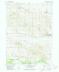
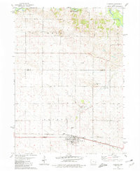
(12)- 1980 Map of Wyoming East, 1981 Print
 1980 Wyoming East1981 Print · USGSEastern Jones County and neighboring Jackson County appear in the late seventies as a landscape of rural schoolhouses and winding creeks. Genealogists and local historians can trace the Old Railroad Grade past Cady Cem or locate the Midland Sch near Monmouth.
 - 1980 Map of Canton, 1981 Print
 1980 Canton1981 Print · USGSThe river valleys of eastern Iowa are captured here in the early 1980s, centered on the historic crossroads of Canton and Clay Mills. Researchers can trace rural lineages through family-named landmarks like Sawyers Rock or sites such as St Peters Ch and Clay Cem.
 - 1980 Map of Wyoming West, 1981 Print
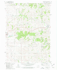
 1980 Wyoming West1981 Print · USGSJones County's agricultural heartland is captured here in the 1980s, centered on the historic town of Wyoming and the southern Wapsipinicon River valley. Genealogists and local historians can trace family locations at North Madison Cem or follow the route of the Chicago Milwaukee St Paul and Pacific rail line.
 - 1980 Map of Monticello, 1981 Print
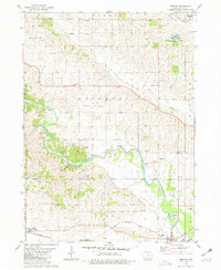
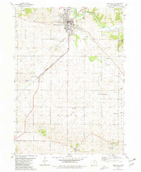 1980 Monticello1981 Print · USGSMonticello and its surrounding townships are captured in the early 1980s, revealing a landscape defined by the river and the rail line. Researchers can trace rural lineages through numerous burial sites and churches, from Oakwood Cem to Edinburg and Zion Ch.
 - 1980 Map of Clarence, 1981 Print
 1980 Clarence1981 Print · USGSClarence and the surrounding Cedar County townships are shown here in the early 1980s, centered on the Chicago and North Western rail corridor. Genealogists can locate several family landmarks and cemeteries such as St Johns Cem and Diamond Cem.
 - 1980 Map of Scotch Grove, 1981 Print
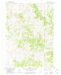
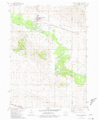
 1980 Scotch Grove1981 Print · USGSJones County comes into focus in the late seventies as the winding river valley meets the rolling Iowa farmland. Genealogists and local historians can trace the foundations of Scotch Grove, locate Johnsontown Cem, and follow the Old Railroad Grade through the bluffs.
 - 1980 Map of Morley, 1981 Print
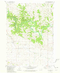
 1980 Morley1981 Print · USGSThe Wapsipinicon River valley in Jones County is captured here in the early eighties, as rail lines still connected the river towns. Researchers can locate the State Penal Farm, Antioch Church, and several rural burial grounds like Graffit Cemetery.
 - 1980 Map of Oxford Junction, 1981 Print
 1980 Oxford Junction1981 Print · USGSJones and Cedar counties come together in the late 1970s as the river-and-rail hub of Oxford Junction anchors the rural landscape. Researchers can trace historic burial sites at Mayflower and Brink Cemeteries or follow the path of the Old River Railroad Grade.
 - 1984 Map of Dubuque South, 1985 Print
 1984 Dubuque South1985 Print · USGSEastern Iowa and Northwest Illinois meet along the Mississippi in the mid-eighties, a landscape defined by river industry and limestone bluffs. Trace the rail lines of the Illinois Central Gulf or explore notable sites like the Savanna Army Depot and Maquoketa Caves State Park.4 unique versions available
 - 1984 Map of Iowa City, 1985 Print
 1984 Iowa City1985 Print · USGSEastern Iowa in the mid-eighties shows a landscape of expanding university towns and river-fed conservation lands. Genealogists and local historians can trace the rural networks connecting Iowa City to smaller outposts like West Branch, Solon, and Atalissa.2 unique versions available
 - 1984 Map of Davenport, 1985 Print
 1984 Davenport1985 Print · USGSThe Quad Cities and the eastern Iowa riverlands are captured in the mid-eighties as industry and conservation converged along the Mississippi. Genealogists and local historians can trace rural roots through Stender Church, Oxford Mills, and the Elmwood Cem burial grounds.2 unique versions available
 - 1984 Map of Anamosa, 1985 Print
 1984 Anamosa1985 Print · USGSEastern Iowa's river valleys and farming communities are captured here in the mid-eighties, showing a landscape defined by the Wapsipinicon River and Maquoketa River. Genealogists and historians can locate legacy landmarks like the Independence State Hospital, Ebys Mill, and the State Penal Farm.2 unique versions available
End of results
Showing maps 1-12 of 12
Top cities of Jones County
- Anamosa historical maps
- Monticello historical maps
- Olin historical maps
- Wyoming historical maps
- Oxford Junction historical maps
- Martelle historical maps
See more
Frequently asked questions
- What are the different types of historical maps available for Jones County?
- What is the oldest map of Jones County?
- Where can I purchase historical maps of Jones County for my home or office?
- Where can I download high-res historical maps of Jones County?
- Are there historical topographic maps available for Jones County?
- Is there historical aerial imagery available for Jones County?
- Where are historical maps of Jones County sourced from?