1980s Maps of Montgomery County, Iowa
Explore 7 historic maps of Montgomery County from the 1980s. These maps offer a rare glimpse into what life looked like during the 1980s — showing old roads, neighborhoods, homes, and landmarks that have changed or disappeared over time.
Whether you're researching your family's past, planning a metal detecting trip, or studying how Montgomery County's landscape evolved across the 1980s, these high-resolution maps are a powerful tool for exploring the history of this region.
- Focus on a specific era: All maps on this page are from the 1980s, giving you a focused view of this time period.
- See what’s changed: Compare century-old streets, trails, and buildings to today's modern landscape using overlays and satellite layers.
- Research with precision: Use these maps for genealogy, historical research, land use analysis, or educational projects.
- View, download, or print: Maps are fully viewable online in high resolution, and can be downloaded or printed for your own records.
Start exploring Montgomery County's history through authentic maps from the 1980s. This is your window into the past.
Montgomery County, IA maps
(7)- 1980 Map of Grant, 1981 Print
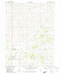 1980 Grant1981 Print · USGSSouthwestern Iowa farm country is documented here in the late seventies, showing the rural communities at the intersections of Montgomery, Cass, and Adams counties. Genealogists can trace family footprints across several rural burial grounds like Old East Cem, Reno Cem, and Newtons Grove Cem.
 - 1980 Map of Villisca, 1981 Print
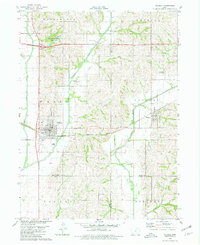 1980 Villisca1981 Print · USGSVillisca and the surrounding Iowa farmland are captured here in the early eighties, showcasing a landscape defined by the three branches of the Nodaway River. Genealogists can locate several local burial sites including Nodaway Cem and Findley Cem, while following the path of the Burlington Northern rail line.
 - 1980 Map of Morton Mills, 1981 Print
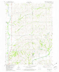 1980 Morton Mills1981 Print · USGSThe river valleys of southwestern Iowa are captured in the late seventies, showing the rural communities of Morton Mills and Sciola along the West Nodaway River. Genealogists can locate family landmarks like Lincoln Center Cem and Strand Ch.
 - 1985 Map of Creston
 1985 Creston1985 Print · USGSSouthwest Iowa in the mid-eighties shows a landscape of established farm towns and growing regional hubs connected by vital rail lines. Genealogists and local historians can trace landmarks like Graceland Cem, the Southwestern Community College campus, and the Burlington Northern railroad route.
 - 1985 Map of Nebraska City
 1985 Nebraska City1985 Print · USGSThe Missouri River borderlands of Nebraska, Iowa, and Missouri come into focus in the mid-1980s, showcasing a landscape of river navigation and rail-fed agriculture. Researchers can trace the heritage of Nebraska City, follow the Burlington Northern tracks, or explore river landmarks like Jones Point and McKissick Island.
 - 1985 Map of Mount Ayr
 1985 Mount Ayr1985 Print · USGSThe Iowa-Missouri borderlands are captured here in the mid-eighties, showing a landscape defined by the branching forks of the Platte River and Grand River. Researchers can trace the heritage of rural communities and conservation sites like Lake of Three Fires State Park and Rose Hill Cemetery.2 unique versions available
 - 1985 Map of Omaha
 1985 Omaha1985 Print · USGSMid-century development and heavy rail infrastructure define the Missouri River corridor between Nebraska and Iowa. Genealogists and local historians can trace the footprints of Offutt Air Force Base, Forest Lawn Cemetery, and the Iowa School for the Deaf.2 unique versions available
End of results
Showing maps 1-7 of 7
Top cities of Montgomery County
- Red Oak historical maps
- Villisca historical maps
- Stanton historical maps
- Elliott historical maps
- Grant historical maps
- Coburg historical maps
Frequently asked questions
- What are the different types of historical maps available for Montgomery County?
- What is the oldest map of Montgomery County?
- Where can I purchase historical maps of Montgomery County for my home or office?
- Where can I download high-res historical maps of Montgomery County?
- Are there historical topographic maps available for Montgomery County?
- Is there historical aerial imagery available for Montgomery County?
- Where are historical maps of Montgomery County sourced from?