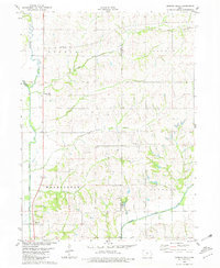
1980 Map of Morton Mills
USGS Topo · Published 1981About this map
Morton Mills sits at the confluence of Sevenmile Creek and the West Nodaway River, serving as a focal point for this agrarian landscape on the border of Montgomery and Adams Counties. The river system dictates the settlement pattern, with smaller hamlets like Sciola and Tenville following the winding valley floor. Further east, the Middle Nodaway River cuts across the southern reach of Lincoln and Douglas townships, passing near the cluster of Dickieville. Significant genealogical sites are noted throughout the uplands, including Lincoln Center Cem and the Strand Ch, which provide a record of the community's early social foundations. The map also documents modern infrastructure cutting through the traditional farm plots, such as the major pipelines traversing the northern townships of Douglas and Lincoln.
Find a feature on this map
21 named features on this map. Tap any name to fly to it.
Don’t see what you’re looking for? This feature index may not catch every label — zoom into the map to look around manually.
Map Details
Editions of this 1980 Morton Mills Map
This is the sole edition of this map. No revisions or reprints were ever made.
Other maps of this area

1954 · Omaha
USGS Topo · 1:250,000

1955 · Nebraska City
USGS Topo · 1:250,000

1957 · Nebraska City
USGS Topo · 1:250,000

1957 · Omaha
USGS Topo · 1:250,000

1958 · Omaha
USGS Topo · 1:250,000

1958 · Nebraska City
USGS Topo · 1:250,000

1978 · Stanton
USGS Topo · 1:24,000

1978 · Wallin
USGS Topo · 1:24,000

1978 · Griswold NE
USGS Topo · 1:24,000

1980 · Grant
USGS Topo · 1:24,000