1970s Maps of Sioux County, Iowa
Explore 6 historic maps of Sioux County from the 1970s. These maps offer a rare glimpse into what life looked like during the 1970s — showing old roads, neighborhoods, homes, and landmarks that have changed or disappeared over time.
Whether you're researching your family's past, planning a metal detecting trip, or studying how Sioux County's landscape evolved across the 1970s, these high-resolution maps are a powerful tool for exploring the history of this region.
- Focus on a specific era: All maps on this page are from the 1970s, giving you a focused view of this time period.
- See what’s changed: Compare century-old streets, trails, and buildings to today's modern landscape using overlays and satellite layers.
- Research with precision: Use these maps for genealogy, historical research, land use analysis, or educational projects.
- View, download, or print: Maps are fully viewable online in high resolution, and can be downloaded or printed for your own records.
Start exploring Sioux County's history through authentic maps from the 1970s. This is your window into the past.
Sioux County, IA maps
(6)- 1971 Map of Inwood, 1973 Print
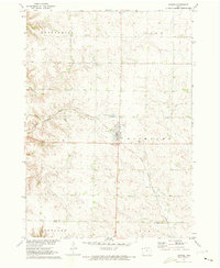 1971 Inwood1973 Print · USGSInwood and its surrounding townships are captured in the early 1970s, as the railroad still dictated the rhythm of this agricultural region. Genealogists can trace family footprints across Richland and Centennial townships, locating Bethlehem Cem and Our Saviors Ch.
 - 1971 Map of George West, 1973 Print
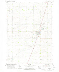
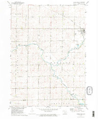 1971 George West1973 Print · USGSNorthwest Iowa's agricultural prairie is captured in the early seventies, centered on the railroad town of George. Genealogists and local historians can trace the Illinois Central rail line, find Evergreen Cem, and locate Hope Ch near the Little Rock River.2 unique versions available
 - 1971 Map of Doon, 1973 Print
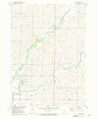 1971 Doon1973 Print · USGSDoon and its surrounding river valleys are captured here in the early seventies during a period of steady agricultural and rail activity. Researchers can trace the Burlington Northern line through town or locate family sites near Township Cem and Lakewood Corner.
 - 1971 Map of Alvord, 1973 Print
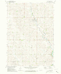 1971 Alvord1973 Print · USGSThe town of Alvord and the surrounding prairie townships are captured here in the early 1970s. Genealogists and local historians can trace family burial sites at St Marys Cem and Hillside Cem or follow the Burlington Northern rail corridor.
 - 1972 Map of Ashton, 1975 Print
 1972 Ashton1975 Print · USGSOsceola County and the town of Ashton are captured in the early seventies, showcasing a landscape of rail-connected commerce and prairie agriculture. Genealogists and local historians can trace family plots at St Marys Cem or locate the site of Willemssen along the county line.
 - 1972 Map of George East, 1975 Print
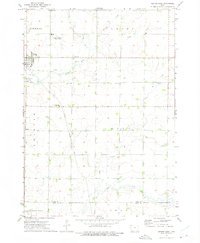 1972 George East1975 Print · USGSNorthwestern Iowa’s agricultural heartland is documented here during the early seventies, centered on the community of George. Researchers can trace the path of the Illinois Central Gulf railroad or locate rural landmarks like Zion Cem and First Baptist Ch.
End of results
Showing maps 1-6 of 6
Top cities of Sioux County
- Sioux Center historical maps
- Orange City historical maps
- Rock Valley historical maps
- Hawarden historical maps
- Hull historical maps
- Alton historical maps
See more
Frequently asked questions
- What are the different types of historical maps available for Sioux County?
- What is the oldest map of Sioux County?
- Where can I purchase historical maps of Sioux County for my home or office?
- Where can I download high-res historical maps of Sioux County?
- Are there historical topographic maps available for Sioux County?
- Is there historical aerial imagery available for Sioux County?
- Where are historical maps of Sioux County sourced from?