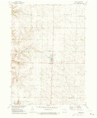
1971 Map of Inwood
USGS Topo · Published 1973About this map
Inwood serves as the central hub of this northwestern Iowa landscape, where the Chicago Milwaukee St Paul and Pacific railroad cuts a diagonal path through the fertile plains of Lyon County. The town is flanked by community landmarks like Foote Park and a nearby Roadside Park, reflecting the local mid-century focus on civic recreation. North of town, the small settlement of Bethlehem and its associated Bethlehem Cem stand alongside Our Saviors Ch, providing critical geographic touchstones for family historians. The terrain is characterized by a high density of rural sections such as Richland, Logan, and Centennial, with the Lyon Co Sioux Co boundary line marking the southern reaches of the survey area. This 1971 record preserves the exact layout of farm access roads and the infrastructure of the Missouri River Basin development program.
Find a feature on this map
19 named features on this map. Tap any name to fly to it.
Don’t see what you’re looking for? This feature index may not catch every label — zoom into the map to look around manually.
Map Details
Editions of this 1971 Inwood Map
This is the sole edition of this map. No revisions or reprints were ever made.
Other maps of this area

1897 · Canton
USGS Topo · 1:125,000

1900 · Canton
USGS Topo · 1:125,000

1955 · Sioux Falls
USGS Topo · 1:250,000

1958 · Sioux Falls
USGS Topo · 1:250,000

1962 · Klondike
USGS Topo · 1:24,000

1962 · Canton
USGS Topo · 1:24,000

1968 · Alcester NE
USGS Topo · 1:24,000

1968 · Fairview
USGS Topo · 1:24,000
1968 · Rock Valley
USGS Topo · 1:24,000

1971 · Lester
USGS Topo · 1:24,000