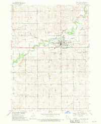
1968 Map of Rock Valley
USGS Topo · Published 1971About this map
The Rock River meanders through the northwest corner of Sioux County, Iowa, defining the landscape of Rock Valley during the late 1960s. This settlement is centered on the Chicago Milwaukee St Paul and Pacific railroad, which provided a critical connection for the agricultural economy. The town infrastructure of this era is clearly marked, including the High Sch, a Hospital, and the Rock Valley Municipal Airport located just south of the main residential grid.
Find a feature on this map
17 named features on this map. Tap any name to fly to it.
Don’t see what you’re looking for? This feature index may not catch every label — zoom into the map to look around manually.
Map Details
Editions of this 1968 Rock Valley Map
This is the sole edition of this map. No revisions or reprints were ever made.
Other maps of this area

1955 · Sioux Falls
USGS Topo · 1:250,000

1958 · Sioux Falls
USGS Topo · 1:250,000

1964 · Sioux Center
USGS Topo · 1:24,000

1964 · Hull
USGS Topo · 1:24,000
1968 · Hawarden North
USGS Topo · 1:24,000

1968 · Fairview
USGS Topo · 1:24,000

1968 · Labanon
USGS Topo · 1:24,000
1971 · Inwood
USGS Topo · 1:24,000

1971 · Doon
USGS Topo · 1:24,000
1971 · Alvord
USGS Topo · 1:24,000