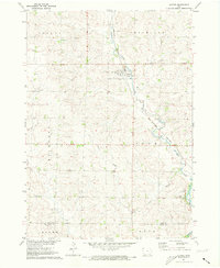
1971 Map of Alvord
USGS Topo · Published 1973About this map
Alvord sits at the junction of rail and stream in this corner of northwest Iowa, where the Burlington Northern railroad follows the valley of Mud Creek. This 1971 survey, conducted for the Missouri River Basin development program, shows a landscape dominated by agricultural sections and the drainage patterns of Lizard Creek. Genealogy researchers can locate several key burial sites, including St Marys Cem and Lutheran Cem just outside the town limits, as well as Hillside Cem further south near the Rock River. The map also documents the local infrastructure of the era, from the Sewage Disposal Pond and Wt (water tower) in town to the various bridge crossings such as BR 1315 and BR 1302 that connect the rural townships of Logan, Cleveland, and Richland.
Find a feature on this map
28 named features on this map. Tap any name to fly to it.
Don’t see what you’re looking for? This feature index may not catch every label — zoom into the map to look around manually.
Map Details
Editions of this 1971 Alvord Map
This is the sole edition of this map. No revisions or reprints were ever made.
Other maps of this area

1955 · Sioux Falls
USGS Topo · 1:250,000

1958 · Sioux Falls
USGS Topo · 1:250,000

1964 · Hull
USGS Topo · 1:24,000

1968 · Fairview
USGS Topo · 1:24,000
1968 · Rock Valley
USGS Topo · 1:24,000

1971 · Lester
USGS Topo · 1:24,000
1971 · Inwood
USGS Topo · 1:24,000
1971 · Larchwood
USGS Topo · 1:24,000

1971 · Rock Rapids
USGS Topo · 1:24,000

1971 · Doon
USGS Topo · 1:24,000