1980s Maps of Wayne County, Iowa
Explore 6 historic maps of Wayne County from the 1980s. These maps offer a rare glimpse into what life looked like during the 1980s — showing old roads, neighborhoods, homes, and landmarks that have changed or disappeared over time.
Whether you're researching your family's past, planning a metal detecting trip, or studying how Wayne County's landscape evolved across the 1980s, these high-resolution maps are a powerful tool for exploring the history of this region.
- Focus on a specific era: All maps on this page are from the 1980s, giving you a focused view of this time period.
- See what’s changed: Compare century-old streets, trails, and buildings to today's modern landscape using overlays and satellite layers.
- Research with precision: Use these maps for genealogy, historical research, land use analysis, or educational projects.
- View, download, or print: Maps are fully viewable online in high resolution, and can be downloaded or printed for your own records.
Start exploring Wayne County's history through authentic maps from the 1980s. This is your window into the past.
Wayne County, IA maps
(6)- 1981 Map of Leon, 1982 Print
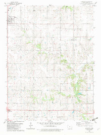
 1981 Leon1982 Print · USGSSouthern Iowa and northern Missouri are captured here in the early eighties as the rural landscape balances traditional agriculture with large-scale water management. Researchers can trace the path of the Burlington Northern through Leon or locate early settlements like Decatur City and New Buda.
 - 1982 Map of Humeston, 1983 Print
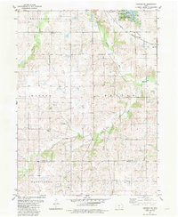
 1982 Humeston1983 Print · USGSWayne County farming communities thrive in the early 1980s as the railroad era transitions to the recreational trail of The Cinder Path. Genealogists can locate several rural burial sites like Greenlee Cem and landmarks such as New Zion Ch.
 - 1982 Map of Corydon, 1983 Print
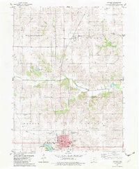 1982 Corydon1983 Print · USGSWayne County comes to life in the early 1980s, centered on the bustling county seat and the rolling drainage of the South Fork Chariton River. Researchers can trace the civic layout of Corydon or locate rural landmarks like Hogue Cem and the small village of New York.
 - 1982 Map of Derby, 1983 Print
 1982 Derby1983 Print · USGSSouthern Iowa's rural landscape is captured here in the early 1980s, centered on the village of Derby. Genealogists and local historians can trace rural family sites like Webb Cem and Woods Cem, or follow the course of The Cinder Path.
 - 1982 Map of Corydon NE, 1983 Print
 1982 Corydon NE1983 Print · USGSThe rural borderlands of Lucas and Wayne Counties are captured here in the early 1980s, centered on the Chariton River valley. Genealogists can trace family locations near Waynick Cem, Salem Ch, and the Burlington Northern rail line.
 - 1982 Map of Melrose, 1983 Print
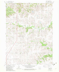
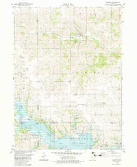 1982 Melrose1983 Print · USGSSouthern Iowa's landscape is captured here in the early eighties as the waters of Rathbun Lake shaped the region's recreation and conservation. Genealogists can locate family landmarks like Mt Calvary Cem and Evans Cem, while tracing the Burlington Northern rail line through Melrose.
End of results
Showing maps 1-6 of 6
Top cities of Wayne County
- Corydon historical maps
- Seymour historical maps
- Humeston historical maps
- Allerton historical maps
- Lineville historical maps
- Promise City historical maps
See more
Frequently asked questions
- What are the different types of historical maps available for Wayne County?
- What is the oldest map of Wayne County?
- Where can I purchase historical maps of Wayne County for my home or office?
- Where can I download high-res historical maps of Wayne County?
- Are there historical topographic maps available for Wayne County?
- Is there historical aerial imagery available for Wayne County?
- Where are historical maps of Wayne County sourced from?