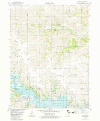
1982 Map of Melrose
USGS Topo · Published 1983About this map
Melrose serves as the primary settlement on this 1980s topographic record, situated along the Burlington Northern railroad corridor. The landscape is defined by the significant southern expanse of Rathbun Lake, an artificial reservoir that dominates the lower half of the map. Surrounding this water body is a network of managed lands including the Rathbun State Wildlife Area and the State Wildlife Refuge, which cover the transition from open water to the wooded creek drainages of Cedar Creek and Blenbaugh Creek. Genealogists will find a cluster of rural burial grounds preserved here, such as Mt Calvary Cem near the town site and the more isolated Milledgeville Cem on the lake's northern shore. The presence of Murphys Landing Strip north of the lake indicates the rural aviation infrastructure of the era, while several sewage disposal ponds reflect the utility requirements for the surrounding townships of Jackson and Independence.
Find a feature on this map
27 named features on this map. Tap any name to fly to it.
Don’t see what you’re looking for? This feature index may not catch every label — zoom into the map to look around manually.
Map Details
Editions of this 1982 Melrose Map
This is the sole edition of this map. No revisions or reprints were ever made.
Other maps of this area

1924 · Melcher
USGS Topo · 1:62,500

1929 · Albia
USGS Topo · 1:62,500

1935 · Russell
USGS Topo · 1:62,500

1938 · Russell
USGS Topo · 1:62,500

1939 · Mystic
USGS Topo · 1:62,500

1942 · Mystic
USGS Topo · 1:62,500

1954 · Centerville
USGS Topo · 1:250,000

1954 · Des Moines
USGS Topo · 1:250,000

1956 · Des Moines
USGS Topo · 1:250,000

1957 · Des Moines
USGS Topo · 1:250,000