1980s Maps of Woodbury County, Iowa
Explore 6 historic maps of Woodbury County from the 1980s. These maps offer a rare glimpse into what life looked like during the 1980s — showing old roads, neighborhoods, homes, and landmarks that have changed or disappeared over time.
Whether you're researching your family's past, planning a metal detecting trip, or studying how Woodbury County's landscape evolved across the 1980s, these high-resolution maps are a powerful tool for exploring the history of this region.
- Focus on a specific era: All maps on this page are from the 1980s, giving you a focused view of this time period.
- See what’s changed: Compare century-old streets, trails, and buildings to today's modern landscape using overlays and satellite layers.
- Research with precision: Use these maps for genealogy, historical research, land use analysis, or educational projects.
- View, download, or print: Maps are fully viewable online in high resolution, and can be downloaded or printed for your own records.
Start exploring Woodbury County's history through authentic maps from the 1980s. This is your window into the past.
Woodbury County, IA maps
(6)- 1985 Map of Storm Lake
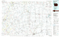
 1985 Storm Lake1985 Print · USGSNorthwest Iowa's agricultural heartland is documented here in the mid-eighties, showing the vital rail-and-river network of the Little Sioux valley. Researchers can trace the legacy of regional hubs and smaller rail towns like Sutherland, Paullina, and Cherokee.3 unique versions available
 - 1985 Map of Ida Grove
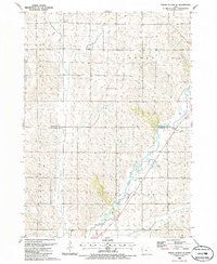
 1985 Ida Grove1985 Print · USGSWestern Iowa's agricultural heartland is documented in the mid-1980s, showcasing a network of grain-hauling rail lines and river valley settlements. Genealogists and historians can trace family locations across Ida Grove and Denison or locate landmarks like Black Hawk Lake.2 unique versions available
 - 1985 Map of Union Center SE, 1986 Print
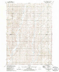
 1985 Union Center SE1986 Print · USGSThe rural borderlands of Woodbury and Plymouth Counties are captured here in the mid-eighties, defined by the winding Little Sioux River. Researchers can trace old property lines across LINCOLN and ARLINGTON townships or locate land markers like Southeast Wildwood County Park and various Gravel Pits.
 - 1985 Map of Union Center SW, 1986 Print
 1985 Union Center SW1986 Print · USGSThe rural borderlands of Plymouth and Woodbury counties are captured here in the mid-1980s, showcasing a landscape of section-line roads and family farms. Researchers can trace the path of the Old RR Gr or locate ancestral sites at Lincoln Cem and Concordia Cem.
 - 1986 Map of Sioux City North
 1986 Sioux City North1986 Print · USGSThe tri-state borderlands of Iowa, South Dakota, and Nebraska are captured here in the mid-eighties as the region's agricultural and academic centers thrived. Researchers can trace historic rail lines like the Illinois Central Gulf and locate landmarks from Briar Cliff College to the heights of Spirit Mound.2 unique versions available
 - 1986 Map of Sioux City South
 1986 Sioux City South1986 Print · USGSThe tri-state borderlands of Iowa, Nebraska, and South Dakota come into focus in the mid-1980s as a landscape of tribal lands and rail corridors. Researchers can trace the extensive boundaries of the Winnebago Indian Reservation and find local landmarks like Morningside College and Martin Field.2 unique versions available
End of results
Showing maps 1-6 of 6
Top cities of Woodbury County
- Sioux City historical maps
- Sergeant Bluff historical maps
- Moville historical maps
- Sloan historical maps
- Lawton historical maps
- Correctionville historical maps
See more
Frequently asked questions
- What are the different types of historical maps available for Woodbury County?
- What is the oldest map of Woodbury County?
- Where can I purchase historical maps of Woodbury County for my home or office?
- Where can I download high-res historical maps of Woodbury County?
- Are there historical topographic maps available for Woodbury County?
- Is there historical aerial imagery available for Woodbury County?
- Where are historical maps of Woodbury County sourced from?