1990s Maps of Woodbury County, Iowa
Explore 4 historic maps of Woodbury County from the 1990s. These maps offer a rare glimpse into what life looked like during the 1990s — showing old roads, neighborhoods, homes, and landmarks that have changed or disappeared over time.
Whether you're researching your family's past, planning a metal detecting trip, or studying how Woodbury County's landscape evolved across the 1990s, these high-resolution maps are a powerful tool for exploring the history of this region.
- Focus on a specific era: All maps on this page are from the 1990s, giving you a focused view of this time period.
- See what’s changed: Compare century-old streets, trails, and buildings to today's modern landscape using overlays and satellite layers.
- Research with precision: Use these maps for genealogy, historical research, land use analysis, or educational projects.
- View, download, or print: Maps are fully viewable online in high resolution, and can be downloaded or printed for your own records.
Start exploring Woodbury County's history through authentic maps from the 1990s. This is your window into the past.
Woodbury County, IA maps
(4)- 1993 Map of Sioux City South, 1995 Print
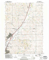
 1993 Sioux City South1995 Print · USGSThe Missouri River tri-state border region comes alive in the early nineties, showing the intersection of Iowa, Nebraska, and South Dakota. Trace community roots through St Michaels Cem, Salem Ch, and the streets of Dakota City.
 - 1993 Map of Sergeant Bluff, 1995 Print
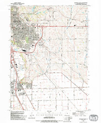 1993 Sergeant Bluff1995 Print · USGSThe Missouri River valley south of Sioux City shows a mix of educational growth and industrial transit in the early nineties. Researchers can trace the development of Sergeant Bluff and locate historic sites like Claypit Cem, Morningside College, and the Old Railroad Grade.
 - 1994 Map of Sioux City North, 1995 Print
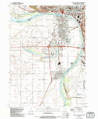
 1994 Sioux City North1995 Print · USGSSioux City and the tri-state border region are mapped here in the mid-nineties as the city grid met the Missouri River bluffs. Genealogists and historians can trace neighborhood schools and cemeteries, from McCook Cem to Bishop Heelan High Sch and Logan Park Cemetery.
 - 1994 Map of James, 1995 Print
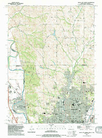
 1994 James1995 Print · USGSThe Floyd River valley north of Sioux City remained a critical transport corridor in the 1990s as suburban growth moved toward the Plymouth County line. Genealogists and local historians can locate the Hungerford Cem and trace the rail lines through James and Leeds.
End of results
Showing maps 1-4 of 4
Top cities of Woodbury County
- Sioux City historical maps
- Sergeant Bluff historical maps
- Moville historical maps
- Sloan historical maps
- Lawton historical maps
- Correctionville historical maps
See more
Frequently asked questions
- What are the different types of historical maps available for Woodbury County?
- What is the oldest map of Woodbury County?
- Where can I purchase historical maps of Woodbury County for my home or office?
- Where can I download high-res historical maps of Woodbury County?
- Are there historical topographic maps available for Woodbury County?
- Is there historical aerial imagery available for Woodbury County?
- Where are historical maps of Woodbury County sourced from?