1970s Maps of Hanlontown, Iowa
Explore 2 historic maps of Hanlontown from the 1970s. These maps offer a rare glimpse into what life looked like during the 1970s — showing old roads, neighborhoods, homes, and landmarks that have changed or disappeared over time.
Whether you're researching your family's past, planning a metal detecting trip, or studying how Hanlontown's landscape evolved across the 1970s, these high-resolution maps are a powerful tool for exploring the history of this region.
- Focus on a specific era: All maps on this page are from the 1970s, giving you a focused view of this time period.
- See what’s changed: Compare century-old streets, trails, and buildings to today's modern landscape using overlays and satellite layers.
- Research with precision: Use these maps for genealogy, historical research, land use analysis, or educational projects.
- View, download, or print: Maps are fully viewable online in high resolution, and can be downloaded or printed for your own records.
Start exploring Hanlontown's history through authentic maps from the 1970s. This is your window into the past.
Hanlontown, IA maps
(2)- 1972 Map of Fertile, 1975 Print
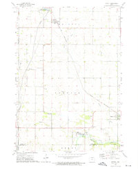 1972 Fertile1975 Print · USGSWorth County farming communities and the rail corridor are captured here during the early seventies. Genealogists and local historians can locate family sites near Elim Cem, Hanlontown, and the Chicago and North Western tracks.
 - 1972 Map of Fertile SE, 1975 Print
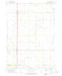 1972 Fertile SE1975 Print · USGSNorthern Iowa farmland in the early seventies centers on the settlement of Hanlontown and the surrounding township sections. Genealogists and local historians can trace family roots through the Elk Grove Cem, Elk Creek Ch, and the old Chicago and North Western rail line.
End of results
Showing maps 1-2 of 2
Top cities near Hanlontown
- Mason City historical maps
- Clear Lake historical maps
- Garner historical maps
- Lake Mills historical maps
- Northwood historical maps
- Manly historical maps
See more
Frequently asked questions
- What are the different types of historical maps available for Hanlontown?
- What is the oldest map of Hanlontown?
- Where can I purchase historical maps of Hanlontown for my home or office?
- Where can I download high-res historical maps of Hanlontown?
- Are there historical topographic maps available for Hanlontown?
- Is there historical aerial imagery available for Hanlontown?
- Where are historical maps of Hanlontown sourced from?