1970s Maps of Allen County, Kansas
Explore 7 historic maps of Allen County from the 1970s. These maps offer a rare glimpse into what life looked like during the 1970s — showing old roads, neighborhoods, homes, and landmarks that have changed or disappeared over time.
Whether you're researching your family's past, planning a metal detecting trip, or studying how Allen County's landscape evolved across the 1970s, these high-resolution maps are a powerful tool for exploring the history of this region.
- Focus on a specific era: All maps on this page are from the 1970s, giving you a focused view of this time period.
- See what’s changed: Compare century-old streets, trails, and buildings to today's modern landscape using overlays and satellite layers.
- Research with precision: Use these maps for genealogy, historical research, land use analysis, or educational projects.
- View, download, or print: Maps are fully viewable online in high resolution, and can be downloaded or printed for your own records.
Start exploring Allen County's history through authentic maps from the 1970s. This is your window into the past.
Allen County, KS maps
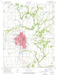
(7)- 1971 Map of Piqua, 1973 Print
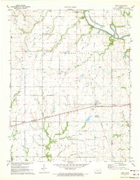 1971 Piqua1973 Print · USGSSoutheast Kansas in the early seventies remains a landscape defined by the Missouri Pacific railroad and steady energy production. Researchers can trace rural life through landmarks like St Martins Sch, the Schaede Cem, and numerous Oil Wells scattered across the prairie.
 - 1971 Map of Neosho Falls, 1973 Print
 1971 Neosho Falls1973 Print · USGSNeosho Falls and the surrounding river valley are detailed in this early 1970s survey as the community thrived along the Neosho. Researchers can trace historic family-named burial sites like Stoeltzing Cem and Cedarvale Cem or locate traces of an Old Railroad Grade.
 - 1971 Map of Yates Center SE, 1973 Print
 1971 Yates Center SE1973 Print · USGSWoodson County at the start of the 1970s reveals a quiet agricultural landscape layered over old boundaries and active oil fields. Genealogists can trace family names at St Marys Cem and Ellison Cem, while historians can locate the Old Indian Treaty Boundary and the tracks of the Missouri Pacific.
 - 1973 Map of Porterville, 1975 Print
 1973 Porterville1975 Print · USGSSoutheastern Kansas in the early 1970s remains a landscape of traditional farmsteads and growing energy extraction. Researchers can trace the Old Indian Treaty Boundary and locate family sites near Harmony Cem or the rural outpost of Porterville.
 - 1973 Map of Chanute, 1975 Print
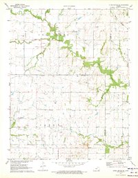
 1973 Chanute1975 Print · USGSChanute and the Neosho River valley appear in high detail during the early 1970s as the local oil and rail industries shaped the landscape. Genealogists and historians can locate several rural burying grounds like Elmwood Cem and Greenwood Cem, alongside the campus of the County Community Junior College.2 unique versions available
 - 1973 Map of Rollin, 1975 Print
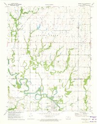
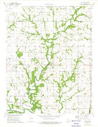 1973 Rollin1975 Print · USGSNeosho and Allen Counties in the early 1970s were characterized by a landscape of productive river bottoms and active petroleum fields. Researchers can locate the Atchison Topeka and Santa Fe rail line, the Odense Cem, and the Big Creek Chapel.
 - 1973 Map of Stark, 1975 Print
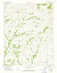
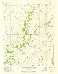 1973 Stark1975 Print · USGSSoutheast Kansas in the early 1970s reveals a structured landscape of prairie farming, oil production, and small-town rail stops. Researchers can trace family history through sites like Friends Home Cem or follow the path of the MISSOURI - KANSAS - TEXAS railroad.
End of results
Showing maps 1-7 of 7
Top cities of Allen County
- Iola historical maps
- Humboldt historical maps
- La Harpe historical maps
- Gas historical maps
- Moran historical maps
- Carlyle historical maps
See more
Frequently asked questions
- What are the different types of historical maps available for Allen County?
- What is the oldest map of Allen County?
- Where can I purchase historical maps of Allen County for my home or office?
- Where can I download high-res historical maps of Allen County?
- Are there historical topographic maps available for Allen County?
- Is there historical aerial imagery available for Allen County?
- Where are historical maps of Allen County sourced from?