1960s Maps of Allen County, Kansas
Explore 14 historic maps of Allen County from the 1960s. These maps offer a rare glimpse into what life looked like during the 1960s — showing old roads, neighborhoods, homes, and landmarks that have changed or disappeared over time.
Whether you're researching your family's past, planning a metal detecting trip, or studying how Allen County's landscape evolved across the 1960s, these high-resolution maps are a powerful tool for exploring the history of this region.
- Focus on a specific era: All maps on this page are from the 1960s, giving you a focused view of this time period.
- See what’s changed: Compare century-old streets, trails, and buildings to today's modern landscape using overlays and satellite layers.
- Research with precision: Use these maps for genealogy, historical research, land use analysis, or educational projects.
- View, download, or print: Maps are fully viewable online in high resolution, and can be downloaded or printed for your own records.
Start exploring Allen County's history through authentic maps from the 1960s. This is your window into the past.
Allen County, KS maps
(14)- 1961 Map of Lawrence
 1961 Lawrence1961 Print · USGSThe Kansas-Missouri borderland shows its mid-century transition from a rail-dependent agricultural region to a suburbanizing landscape. Genealogists can trace family footprints through numerous Cem sites and distinctive terrain landmarks like Graves Mound and Summers Mound.
 - 1963 Map of Vilas, 1964 Print
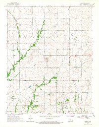
 1963 Vilas1964 Print · USGSSoutheast Kansas in the early sixties was a landscape of rail-connected small towns and rural school districts. Genealogists and historians can trace family roots through sites like Vilas, the Vilas Bethel Cem, and the Union Valley Sch.
 - 1965 Map of Iola SE, 1967 Print
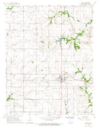
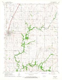
 1965 Iola SE1967 Print · USGSSoutheast of Iola in the mid-1960s, the rural Kansas landscape remained anchored by its oil fields and historical borders. Researchers can trace the Old Indian Treaty Boundary and locate local landmarks like Zillah Sch and Maple Grove Cem.
 - 1965 Map of La Harpe, 1967 Print
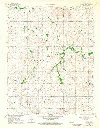
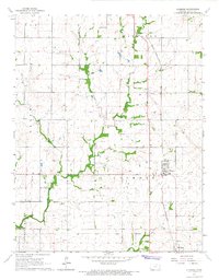
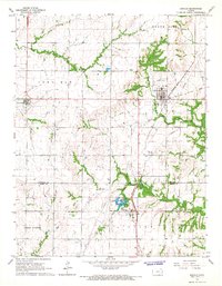
 1965 La Harpe1967 Print · USGSLa Harpe and the surrounding Allen County prairies are captured here in the mid-1960s as industrial and transit patterns were shifting. Researchers can trace the Missouri Pacific line, locate the La Harpe Cem, or find the old Drive-in Theater.2 unique versions available
 - 1966 Map of Moran SE, 1967 Print
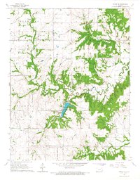 1966 Moran SE1967 Print · USGSBourbon County rural life in the mid-1960s is centered on the Marmaton River and the emerging recreation at Bourbon County State Park. Trace family history at Mason Cem or follow the path of the Old Railroad Grade.
 - 1966 Map of Elsmore, 1967 Print
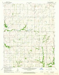
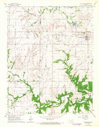
 1966 Elsmore1967 Print · USGSAllen County saw a landscape of active energy production and rail transit during the mid-sixties. Researchers can locate family roots at Old Elsmore Cem, trace the Missouri - Kansas - Texas line, or find the Old Indian Treaty Boundary.
 - 1966 Map of Humboldt, 1967 Print
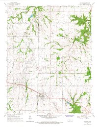
 1966 Humboldt1967 Print · USGSThe Neosho River valley in the mid-1960s reveals a landscape of railroad junctions and oil production surrounding Humboldt. Researchers can locate numerous family burial sites like Kerns Cemetery and trace the path of the Old Indian Treaty Boundary.2 unique versions available
 - 1966 Map of Bronson, 1967 Print
 1966 Bronson1967 Print · USGSThe rural border of Allen and Bourbon counties is captured in the mid-1960s, showing the intersection of local industry and railroad history. Researchers can trace the Missouri Pacific line through Bronson or locate ancestral sites like South Osage Cem and Ensminger Cem.
 - 1966 Map of Moran, 1967 Print
 1966 Moran1967 Print · USGSMid-century Moran and Bayard appear here during a period of active rail transport and resource extraction. Researchers can trace the intersection of the Missouri Pacific and Missouri - Kansas - Texas lines or locate the Golden Valley Ch and Moran Cem.
 - 1966 Map of Iola, 1967 Print
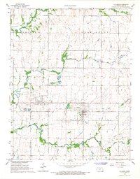
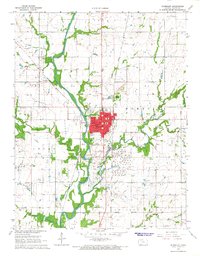
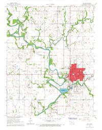 1966 Iola1967 Print · USGSIola and the Neosho River valley are captured in the mid-1960s during a period of steady industrial and rail activity. Researchers can trace local lineage and landmarks through Highland Cemetery, Salem Ch, and the many rural schoolhouses like West Neosho Sch.2 unique versions available
 - 1966 Map of Geneva, 1967 Print
 1966 Geneva1967 Print · USGSThe rural borders of Anderson and Allen Counties come into focus during the mid-1960s, showing a landscape defined by prairie creeks and fossil fuel extraction. Researchers can locate family landmarks like Northcott Ch and Geneva Cem or trace the path of the Atchison Topeka and Santa Fe railroad.
 - 1966 Map of Kincaid, 1967 Print
 1966 Kincaid1967 Print · USGSThe rural landscape of Anderson and Allen Counties is captured here in the mid-1960s, showing the agricultural and industrial heart of eastern Kansas. Genealogists and historians can trace the Missouri - Kansas - Texas Railroad and locate community landmarks like Fairview Chapel and Mt Zion Cem.2 unique versions available
 - 1966 Map of Colony, 1967 Print
 1966 Colony1967 Print · USGSAnderson and Allen Counties show a landscape of shifting industry and rail transit during the mid-1960s. Researchers can trace the legacy of local transport via the Atchison Topeka and Santa Fe or find family roots at Pleasant Valley Cem.
 - 1966 Map of Blue Mound, 1967 Print
 1966 Blue Mound1967 Print · USGSThe rural landscape of Linn and Anderson counties comes into focus in the mid-1960s, centered on the town of Blue Mound. Genealogists and historians can trace an Old Railroad Grade and several burial sites like Osage Cem and Boulware Cem.
End of results
Showing maps 1-14 of 14
Top cities of Allen County
- Iola historical maps
- Humboldt historical maps
- La Harpe historical maps
- Gas historical maps
- Moran historical maps
- Carlyle historical maps
See more
Frequently asked questions
- What are the different types of historical maps available for Allen County?
- What is the oldest map of Allen County?
- Where can I purchase historical maps of Allen County for my home or office?
- Where can I download high-res historical maps of Allen County?
- Are there historical topographic maps available for Allen County?
- Is there historical aerial imagery available for Allen County?
- Where are historical maps of Allen County sourced from?