1960s Maps of Brown County, Kansas
Explore 17 historic maps of Brown County from the 1960s. These maps offer a rare glimpse into what life looked like during the 1960s — showing old roads, neighborhoods, homes, and landmarks that have changed or disappeared over time.
Whether you're researching your family's past, planning a metal detecting trip, or studying how Brown County's landscape evolved across the 1960s, these high-resolution maps are a powerful tool for exploring the history of this region.
- Focus on a specific era: All maps on this page are from the 1960s, giving you a focused view of this time period.
- See what’s changed: Compare century-old streets, trails, and buildings to today's modern landscape using overlays and satellite layers.
- Research with precision: Use these maps for genealogy, historical research, land use analysis, or educational projects.
- View, download, or print: Maps are fully viewable online in high resolution, and can be downloaded or printed for your own records.
Start exploring Brown County's history through authentic maps from the 1960s. This is your window into the past.
Brown County, KS maps
(17)- 1960 Map of Kansas City
 1960 Kansas City1960 Print · USGSMid-century Kansas and Missouri meet at the river forks, showing a sprawling rail-and-river economy during the 1950s growth era. Genealogists and researchers can trace tribal lands like the Kickapoo Indian Reservation or follow the early interstate corridors through Saint Joseph and Independence.3 unique versions available
 - 1960 Map of Sabetha, 1961 Print
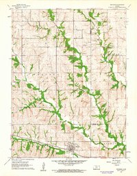
 1960 Sabetha1961 Print · USGSSabetha sits at the crossroads of two major rail lines during the early sixties, anchoring a landscape of small Kansas townships and creek-fed valleys. Genealogists and historians can trace old landmarks like the Albany Cemetery, Berwick School, and the Sabetha Municipal Landing Field.
 - 1960 Map of Fairview, 1961 Print
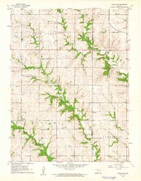
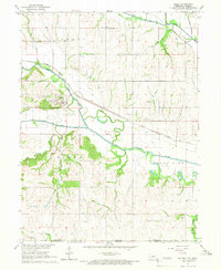
 1960 Fairview1961 Print · USGSBrown County's agricultural heartland is documented here at the start of the 1960s, showing a landscape defined by rail and river. Researchers can trace the path of the CHICAGO ROCK ISLAND AND PACIFIC or locate family sites like Lambertson Cem and the OLD INDIAN BOUNDARY.
 - 1960 Map of Horton NW, 1961 Print
 1960 Horton NW1961 Print · USGSThe Kickapoo Indian Reservation and the rural borderlands of Brown and Jackson counties are documented here in the early sixties. Researchers can trace the placement of the Kickapoo Indian Ch, School No 44, and the community of Greggs.
 - 1960 Map of Reserve, 1962 Print
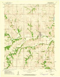
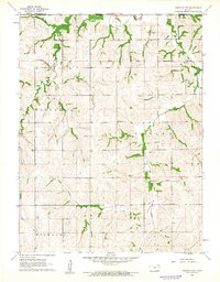
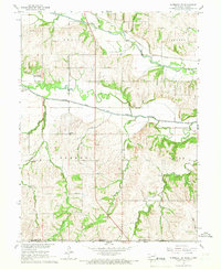
 1960 Reserve1962 Print · USGSBrown County, Kansas, is captured at the start of the 1960s, showing a landscape shaped by rail lines and tribal boundaries. Researchers can trace family history at Cornelison Cem or locate rural landmarks like Hart Sch and the community of Reserve.
 - 1961 Map of Robinson, 1962 Print
 1961 Robinson1962 Print · USGSBrown County's rural townships are captured here in the early sixties, showing the agricultural and rail-based landscape around Robinson. Researchers can trace old school districts like La Grange Sch or locate the Upper Wolf Ch and Rose Hill Cem.2 unique versions available
 - 1961 Map of Hiawatha, 1962 Print
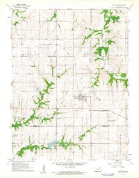
 1961 Hiawatha1962 Print · USGSHiawatha and its surrounding prairie townships are captured here in the early sixties at a peak of rail-driven commerce. Researchers can trace the Old Indian Boundary, local schools like Union Sch, and the grounds of the Mt Hope Cemetery.2 unique versions available
 - 1961 Map of Everest, 1962 Print
 1961 Everest1962 Print · USGSThe agricultural landscape of northeast Kansas is captured here in the early sixties, centered on the rail hub of Everest. Researchers can trace old family sites and rural landmarks like Zion Ch, Kennekuk Cem, and the path of the Wolf River.2 unique versions available
 - 1961 Map of Denton, 1962 Print
 1961 Denton1962 Print · USGSNortheast Kansas farmland at the start of the sixties reveals a landscape of tight-knit rural townships and competing rail lines. Genealogists and local historians can trace family roots through several small burial sites like Anderson Cemetery and locate vanished landmarks like the High Prairie School.2 unique versions available
 - 1961 Map of Wetmore, 1962 Print
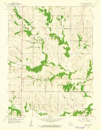
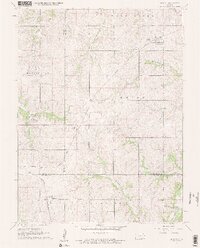
 1961 Wetmore1962 Print · USGSWetmore and the surrounding townships are captured in the early sixties as a thriving rail and agricultural corridor. Genealogists and local historians can trace the foundations of this rural community through the Granada Cem, the Powhattan Cem, and the path of the Missouri Pacific line.
 - 1961 Map of Highland NW, 1962 Print
 1961 Highland NW1962 Print · USGSThe Kansas-Nebraska borderlands in the early sixties reveal a landscape defined by the Iowa Sac and Fox Indian Reservation Boundary and rural townships. Trace local family history through landmarks like Kenyon Cem, Mt Zion Ch, and the Shore Sch.
 - 1961 Map of Woodlawn, 1962 Print
 1961 Woodlawn1962 Print · USGSNortheastern Kansas is shown here in the early sixties, split by the Nemaha and Brown county lines. Genealogists and historians can trace family locations near Woodlawn, Capioma, and Fidelity, or locate the Woodlawn Cem and local Quarries.
 - 1961 Map of Horton, 1962 Print
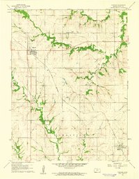
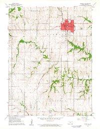
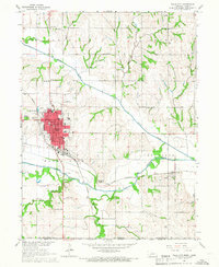
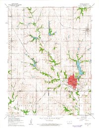 1961 Horton1962 Print · USGSHorton was a bustling rail hub in the early sixties, anchored by two major lines and a growing municipal footprint. Genealogists and local historians can locate St Peters Cem, the vanished tracks of the Missouri Pacific, and the old Mission Lake Camp.
 - 1965 Map of Salem, 1966 Print
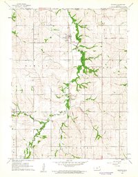
 1965 Salem1966 Print · USGSThe river valley at Salem and Straussville is captured here in the mid-sixties, showing the convergence of the Big Nemaha River and its forks. Genealogists and historians can locate rural landmarks like St Marks Ch, Maple Cem, and Falls Sch among the railroad networks.
 - 1965 Map of Falls City, 1966 Print
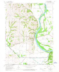
 1965 Falls City1966 Print · USGSRichardson County in the mid-1960s shows a thriving rail-and-river hub centered on the Missouri River basin. Genealogists and local historians can trace family roots through rural landmarks like Gladstone Sch, Steele Cemetery, and the Iowa and Sac and Fox Indian Reservation Boundary.2 unique versions available
 - 1965 Map of Rulo, 1966 Print
 1965 Rulo1966 Print · USGSThe river bluffs and bottomlands of Rulo come alive in the mid-1960s as the rail-and-river economy transitions into the modern era. Trace the path of the Chicago Burlington and Quincy railroad or locate local landmarks like Heater Cem and Brick Sch.
 - 1965 Map of Humboldt SE, 1967 Print
 1965 Humboldt SE1967 Print · USGSThe Nebraska-Kansas border comes alive in the mid-sixties as the Big Nemaha River branches across Richardson County farmland. Researchers can locate the Miles Ranch, trace the rail lines of the Chicago Burlington and Quincy, and find family sites like Wild Rose Cem.
End of results
Showing maps 1-17 of 17
Top cities of Brown County
- Hiawatha historical maps
- Horton historical maps
- Everest historical maps
- Fairview historical maps
- Morrill historical maps
- Padonia historical maps
See more
Frequently asked questions
- What are the different types of historical maps available for Brown County?
- What is the oldest map of Brown County?
- Where can I purchase historical maps of Brown County for my home or office?
- Where can I download high-res historical maps of Brown County?
- Are there historical topographic maps available for Brown County?
- Is there historical aerial imagery available for Brown County?
- Where are historical maps of Brown County sourced from?