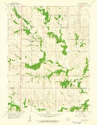
1960 Map of Horton NW
USGS Topo · Published 1961About this map
The Kickapoo Indian Reservation Boundary bisects this Kansas landscape, defining a rural territory at the intersection of Brown and Jackson counties. The 1960 field check reveals a community anchored by local institutions, including the Kickapoo Indian Ch and educational landmarks like School No 44 and Gray Sch. The drainage of the Delaware River and its tributaries, such as Squaw Creek and Plum Creek, dictates the wooded patterns and agricultural layout of the region.
Find a feature on this map
15 named features on this map. Tap any name to fly to it.
Don’t see what you’re looking for? This feature index may not catch every label — zoom into the map to look around manually.
Map Details
Editions of this 1960 Horton NW Map
This is the sole edition of this map. No revisions or reprints were ever made.
Other maps of this area

1888 · Hiawatha
USGS Topo · 1:125,000

1894 · Hiawatha
USGS Topo · 1:125,000

1950 · Kansas City
USGS Topo · 1:250,000

1954 · Kansas City
USGS Topo · 1:250,000

1956 · Kansas City
USGS Topo · 1:250,000

1960 · Kansas City
USGS Topo · 1:250,000

1960 · Fairview
USGS Topo · 1:24,000
1961 · Hiawatha
USGS Topo · 1:24,000
1961 · Netawaka
USGS Topo · 1:24,000
1961 · Circleville
USGS Topo · 1:24,000