1961 Map of Hiawatha
USGS Topo · Published 1962About this map
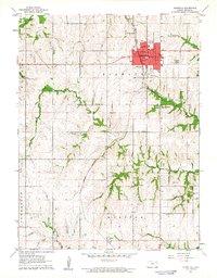
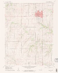
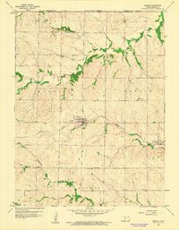
Hiawatha serves as the focal point of this Kansas prairie landscape, situated at the junction of the Missouri Pacific and Union Pacific railroads. The town's grid is dense with civic infrastructure, including the Courthouse, Armory, and Hospital. A distinct cultural footprint is visible just south of the city center, where the Hiawatha Country Club, Lake Hiawatha, and a Drive-in Theater cluster along the highway.
Find a feature on this map
28 named features on this map. Tap any name to fly to it.
Don’t see what you’re looking for? This feature index may not catch every label — zoom into the map to look around manually.
Map Details
Editions of this 1961 Hiawatha Map
2 editions found
Other maps of this area

1885 · Atchison
USGS Topo · 1:125,000

1888 · Atchison
USGS Topo · 1:125,000

1888 · Hiawatha
USGS Topo · 1:125,000

1893 · Atchison
USGS Topo · 1:125,000

1894 · Hiawatha
USGS Topo · 1:125,000

1950 · Kansas City
USGS Topo · 1:250,000

1954 · Kansas City
USGS Topo · 1:250,000

1956 · Kansas City
USGS Topo · 1:250,000
1959 · Morrill
USGS Topo · 1:24,000

1960 · Kansas City
USGS Topo · 1:250,000