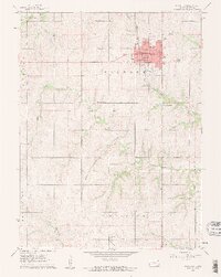
1961 Map of Hiawatha
USGS Topo · Published 1962About this map
Hiawatha serves as the central hub of this Brown County landscape, positioned at the intersection of the Union Pacific and Missouri Pacific railroads. The town's local significance is evident in its concentration of civic architecture, including the Courthouse, Armory, and High Sch. To the south, the Old Indian Boundary cuts a diagonal line across the township divisions, marking a significant historical border that predates the established section lines.
Find a feature on this map
30 named features on this map. Tap any name to fly to it.
Don’t see what you’re looking for? This feature index may not catch every label — zoom into the map to look around manually.
Map Details
Editions of this 1961 Hiawatha Map
2 editions found
Other maps of this area

1885 · Atchison
USGS Topo · 1:125,000

1888 · Atchison
USGS Topo · 1:125,000

1888 · Hiawatha
USGS Topo · 1:125,000

1893 · Atchison
USGS Topo · 1:125,000

1894 · Hiawatha
USGS Topo · 1:125,000

1950 · Kansas City
USGS Topo · 1:250,000

1954 · Kansas City
USGS Topo · 1:250,000

1956 · Kansas City
USGS Topo · 1:250,000
1959 · Morrill
USGS Topo · 1:24,000

1960 · Kansas City
USGS Topo · 1:250,000