1980s Maps of Cheyenne County, Kansas
Explore 9 historic maps of Cheyenne County from the 1980s. These maps offer a rare glimpse into what life looked like during the 1980s — showing old roads, neighborhoods, homes, and landmarks that have changed or disappeared over time.
Whether you're researching your family's past, planning a metal detecting trip, or studying how Cheyenne County's landscape evolved across the 1980s, these high-resolution maps are a powerful tool for exploring the history of this region.
- Focus on a specific era: All maps on this page are from the 1980s, giving you a focused view of this time period.
- See what’s changed: Compare century-old streets, trails, and buildings to today's modern landscape using overlays and satellite layers.
- Research with precision: Use these maps for genealogy, historical research, land use analysis, or educational projects.
- View, download, or print: Maps are fully viewable online in high resolution, and can be downloaded or printed for your own records.
Start exploring Cheyenne County's history through authentic maps from the 1980s. This is your window into the past.
Cheyenne County, KS maps
(9)- 1981 Map of Bird City South NW
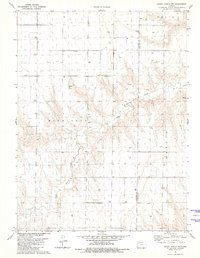
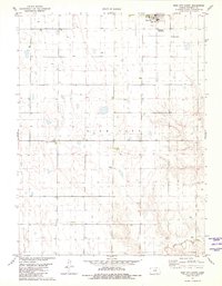
 1981 Bird City South NW1981 Print · USGSThe High Plains of Cheyenne County are captured here in the early eighties, showing a landscape defined by industrial agriculture and township grids. Researchers can locate Wheeler Cem, St Pauls Cem, and sand extraction sites along Sand Creek.
 - 1981 Map of Dewey Ranch SW
 1981 Dewey Ranch SW1981 Print · USGSThe high plains of Northwest Kansas are captured here in the early 1980s, where the corners of four different counties meet. Genealogists and historians can locate remote landmarks like Fairview Cem, Central Ch, and the workings of the Llanos Oil Field.
 - 1981 Map of Bird City South SW
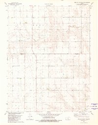 1981 Bird City South SW1981 Print · USGSNorthwestern Kansas in the early eighties shows a landscape of precision-mapped sections and essential water resources. Researchers can trace the winding path of Little Beaver Creek through the townships of Wano and Voltaire to find historic well sites.
 - 1981 Map of Dewey Ranch NW
 1981 Dewey Ranch NW1981 Print · USGSHigh plains topography and county line divisions define this northwest Kansas landscape during the early 1980s. Researchers can trace the drainage of Little Beaver Creek and locate early resource sites including a Quarry and numerous Well locations.
 - 1981 Map of Bird City South
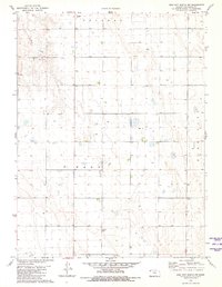
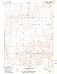
 1981 Bird City South1981 Print · USGSHigh Plains agriculture and aviation intersect in this early 1980s survey of Cheyenne County. Researchers can trace local heritage at Greisler Cem or locate vintage infrastructure like the Community Landing Field and Gilliland Landing Strip.
 - 1981 Map of Bird City South SE
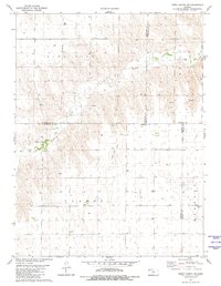
 1981 Bird City South SE1981 Print · USGSThe High Plains of the Kansas borderlands are captured in the early eighties, showing the agricultural landscape across the Cheyenne and Sherman County line. Local researchers can locate the Sunnyside Cem, the Bursch Landing Strip, and the settlement of Kehlbeck.
 - 1981 Map of Wray, 1982 Print
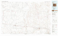 1981 Wray1982 Print · USGSThe high plains at the meeting of Colorado, Nebraska, and Kansas are documented here in the early 1980s. Local researchers can trace the Burlington Northern rail corridor and locate rural landmarks like Lone Star, Glocken Hill, and Dearing Lake.
 - 1983 Map of Bonny Reservoir, 1984 Print
 1983 Bonny Reservoir1984 Print · USGSThe high plains of eastern Colorado and western Kansas appear here in the early eighties, centered on the vital waters of Bonny Reservoir. Genealogists and local historians can trace small prairie settlements like Idalia, Kirk, and the historic site of Beecher Island.
 - 1985 Map of St. Francis
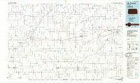 1985 St. Francis1985 Print · USGSNorthwest Kansas in the mid-1980s shows a classic High Plains settlement pattern anchored by the Burlington Northern rail line. Genealogists and researchers can trace local landmarks from St Francis to Atwood, including rural aviation sites like Bird City's landing field and the St Francis State Wildlife Management Area.2 unique versions available
End of results
Showing maps 1-9 of 9
Top cities of Cheyenne County
Frequently asked questions
- What are the different types of historical maps available for Cheyenne County?
- What is the oldest map of Cheyenne County?
- Where can I purchase historical maps of Cheyenne County for my home or office?
- Where can I download high-res historical maps of Cheyenne County?
- Are there historical topographic maps available for Cheyenne County?
- Is there historical aerial imagery available for Cheyenne County?
- Where are historical maps of Cheyenne County sourced from?