1970s Maps of Cheyenne County, Kansas
Explore 17 historic maps of Cheyenne County from the 1970s. These maps offer a rare glimpse into what life looked like during the 1970s — showing old roads, neighborhoods, homes, and landmarks that have changed or disappeared over time.
Whether you're researching your family's past, planning a metal detecting trip, or studying how Cheyenne County's landscape evolved across the 1970s, these high-resolution maps are a powerful tool for exploring the history of this region.
- Focus on a specific era: All maps on this page are from the 1970s, giving you a focused view of this time period.
- See what’s changed: Compare century-old streets, trails, and buildings to today's modern landscape using overlays and satellite layers.
- Research with precision: Use these maps for genealogy, historical research, land use analysis, or educational projects.
- View, download, or print: Maps are fully viewable online in high resolution, and can be downloaded or printed for your own records.
Start exploring Cheyenne County's history through authentic maps from the 1970s. This is your window into the past.
Cheyenne County, KS maps
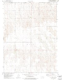
(17)- 1971 Map of Hale Ponds, 1973 Print
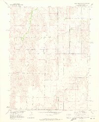
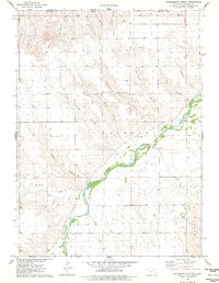
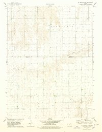
 1971 Hale Ponds1973 Print · USGSThe high plains on the Colorado and Kansas border are documented here in the early seventies, showcasing a rural landscape defined by the South Fork Republican River. Genealogists can locate family landmarks such as Gilstrap Cem, Zion Cem, and the church at Armel.
 - 1971 Map of Bonny Reservoir SE, 1973 Print
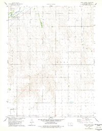
 1971 Bonny Reservoir SE1973 Print · USGSThe Colorado-Kansas borderlands are captured here in the early seventies, showing a remote landscape of high plains ranching and intricate drainage systems. Genealogists and land historians can trace property boundaries and water rights along Beaver Creek, Battle Creek, and Jaqua Creek.2 unique versions available
 - 1976 Map of Bird City North, 1978 Print
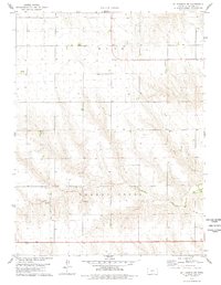
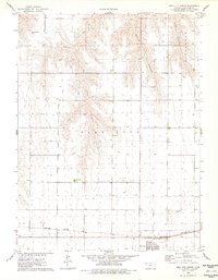 1976 Bird City North1978 Print · USGSBird City in the mid-1970s is a center of commerce and transport along the High Plains. Genealogists and local historians can trace the Burlington Northern rail corridor and find local landmarks like the Bird City Cem and Big Timber Creek.
 - 1976 Map of White Canyon, 1978 Print
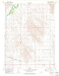
 1976 White Canyon1978 Print · USGSCheyenne County, Kansas, and the Nebraska borderlands are captured here in the late seventies. Family history and land use researchers can locate the Hackberry Cem, old Sandpits, and the rugged drainage patterns of White Canyon.
 - 1976 Map of Henkle Canyon, 1978 Print
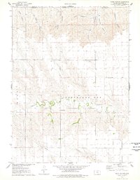
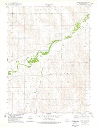
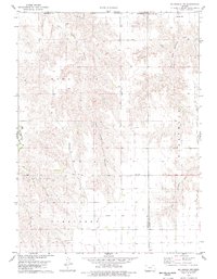
 1976 Henkle Canyon1978 Print · USGSCheyenne County, Kansas, is captured in the mid-1970s, showcasing a landscape defined by the winding South Fork Republican River. Researchers can locate rural homesteads near Lowe, the high point at Mt Hope, and deep drainages like Henkle Canyon and Devils Canyon.
 - 1976 Map of Heinzelman Canyon, 1978 Print
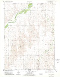
 1976 Heinzelman Canyon1978 Print · USGSCheyenne County, Kansas, is captured in the mid-seventies just south of the Nebraska border as the South Fork Republican River carves through the plains. Researchers can locate local landmarks like the South Fork Ch and rural points such as Kettler and Douthit.
 - 1978 Map of St Francis
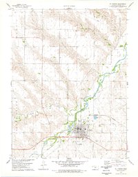 1978 St Francis1978 Print · USGSThe Kansas high plains meet the winding forks of the Republican River in the late seventies. Researchers can trace local genealogy at Zion Cem and G A R Cem or follow the transition from the Old Railroad Grade to active rail lines.
 - 1978 Map of Crosby Creek
 1978 Crosby Creek1978 Print · USGSCheyenne County, Kansas, is captured in the late seventies as a landscape of river valleys and high plains agriculture. Genealogists and local historians can locate rural landmarks like Zion Cem, Battle Creek Cem, and the long-abandoned Old Railroad Grade.
 - 1978 Map of St. Francis 3 SE
 1978 St. Francis 3 SE1978 Print · USGSNorthwest Kansas in the late 1970s shows a landscape of expansive townships and high-plains water management. Genealogists and researchers can trace land divisions across Benkelman and Voltaire or locate features like Little Beaver Creek.2 unique versions available
 - 1978 Map of St Francis NW
 1978 St Francis NW1978 Print · USGSCheyenne County, Kansas, is shown in the late 1970s as a landscape of deep canyons and quiet prairie cemeteries along the Nebraska border. Researchers can trace family roots at Hope Valley Cem and Emanuel Cem or follow the path of Hackberry Creek.
 - 1978 Map of Drury Creek
 1978 Drury Creek1978 Print · USGSCheyenne County ranching and river lands are documented here in the late seventies. Genealogists and local researchers can locate the Lawn Ridge Cem, follow the Old Railroad Grade, and trace the path of Drury Creek.
 - 1978 Map of St Francis SW
 1978 St Francis SW1978 Print · USGSThe High Plains of western Kansas are documented here in the late seventies, showing the township of Wano and its rural foundations. Researchers can trace local lineage at Salem Cem and locate landmarks like Salem Ch and Cherry Creek.
 - 1978 Map of Wheeler
 1978 Wheeler1978 Print · USGSCheyenne County, Kansas, is documented here in the late seventies as the agricultural landscape of the High Plains continued to evolve. Researchers can trace the Burlington Northern rail line through Wheeler or locate the Barley Cem and South Fork Republican River.
 - 1978 Map of St. Francis 3 SW
 1978 St. Francis 3 SW1978 Print · USGSHigh plains ranching and agriculture define this western Kansas borderland in the late seventies. Genealogists and local historians can trace the rural landscape across Benkelman and Jaqua, locating landmarks like Neville Ch and the headwaters of Battle Creek.3 unique versions available
 - 1978 Map of Mc Donald NW, 1979 Print
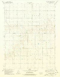
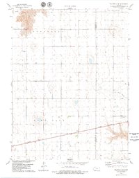
 1978 Mc Donald NW1979 Print · USGSCheyenne County, Kansas, is documented here in the late seventies, showing the rural landscape just south of the Nebraska border. Researchers can locate small local centers like David and Mears or trace the drainage of the West Fork Burntwood Creek.
 - 1978 Map of Mc Donald SW, 1979 Print
 1978 Mc Donald SW1979 Print · USGSThe High Plains of Cheyenne County are shown in the late seventies, just as the agricultural landscape was maturing. Researchers can find rural burial grounds like Evergreen Cem and follow the path of the Burlington Northern railroad near North Beaver Cr.
 - 1979 Map of Benkelman
 1979 Benkelman1979 Print · USGSSouthwestern Nebraska in the late seventies is shown as a network of river-valley towns and high-plains ranching country. Genealogists and researchers can trace the rail corridor through Benkelman, Culbertson, and Haigler, or locate the reservoir lands at Enders.
End of results
Showing maps 1-17 of 17
Top cities of Cheyenne County
Frequently asked questions
- What are the different types of historical maps available for Cheyenne County?
- What is the oldest map of Cheyenne County?
- Where can I purchase historical maps of Cheyenne County for my home or office?
- Where can I download high-res historical maps of Cheyenne County?
- Are there historical topographic maps available for Cheyenne County?
- Is there historical aerial imagery available for Cheyenne County?
- Where are historical maps of Cheyenne County sourced from?