1960s Maps of Green, Kansas
Explore 2 historic maps of Green from the 1960s. These maps offer a rare glimpse into what life looked like during the 1960s — showing old roads, neighborhoods, homes, and landmarks that have changed or disappeared over time.
Whether you're researching your family's past, planning a metal detecting trip, or studying how Green's landscape evolved across the 1960s, these high-resolution maps are a powerful tool for exploring the history of this region.
- Focus on a specific era: All maps on this page are from the 1960s, giving you a focused view of this time period.
- See what’s changed: Compare century-old streets, trails, and buildings to today's modern landscape using overlays and satellite layers.
- Research with precision: Use these maps for genealogy, historical research, land use analysis, or educational projects.
- View, download, or print: Maps are fully viewable online in high resolution, and can be downloaded or printed for your own records.
Start exploring Green's history through authentic maps from the 1960s. This is your window into the past.
Green, KS maps
(2)- 1963 Map of Lasita, 1965 Print
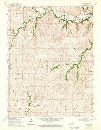 1963 Lasita1965 Print · USGSThe rural landscape along the Clay and Riley County line is captured here in the early sixties, showing the agricultural heartland before modern consolidation. Genealogists can locate family landmarks like Ebenezer Cem, May Day Cem, and the path of the Old Railroad Grade.2 unique versions available
 - 1964 Map of Clay Center NE, 1965 Print
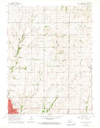 1964 Clay Center NE1965 Print · USGSClay County at the start of the 1960s reveals a landscape of established townships and evolving transport. Genealogists and local historians can trace the Old Railroad Grade near Green or locate family sites like Hayes Cem and the Brethren in Christ Cem.
End of results
Showing maps 1-2 of 2
Top cities near Green
- Clay Center historical maps
- Wakefield historical maps
- Riley historical maps
- Bala historical maps
- Leonardville historical maps
- Morganville historical maps
See more
Frequently asked questions
- What are the different types of historical maps available for Green?
- What is the oldest map of Green?
- Where can I purchase historical maps of Green for my home or office?
- Where can I download high-res historical maps of Green?
- Are there historical topographic maps available for Green?
- Is there historical aerial imagery available for Green?
- Where are historical maps of Green sourced from?