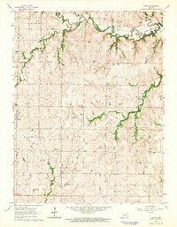
1963 Map of Lasita
USGS Topo · Published 1965About this map
Fancy Creek and its tributary, West Fancy Creek, carve through this landscape along the Clay Co Riley Co line in the early 1960s. The settlement of Lasita sits near the center of the sheet, while the town of Green occupies the western edge, surrounded by a network of rural schools and churches that defined the social geography of the era. Evidence of a changing infrastructure is visible in the Old Railroad Grade traversing the southern portion of the map, and the emergence of the Tuttle Creek Reservoir in the northeast corner, which began altering the local drainage patterns. Significant landmarks for local history include several dedicated burial grounds such as May Day Cem and Fancy Creek Cem, alongside rural educational centers like Pleasant Hill Sch and Fairview Sch.
Find a feature on this map
21 named features on this map. Tap any name to fly to it.
Don’t see what you’re looking for? This feature index may not catch every label — zoom into the map to look around manually.
Map Details
Editions of this 1963 Lasita Map
2 editions found
Other maps of this area

1886 · Junction City
USGS Topo · 1:125,000

1889 · Marysville
USGS Topo · 1:125,000

1889 · Junction City
USGS Topo · 1:125,000

1891 · Clay Center
USGS Topo · 1:125,000

1893 · Washington
USGS Topo · 1:125,000

1894 · Junction City
USGS Topo · 1:125,000

1894 · Marysville
USGS Topo · 1:125,000

1955 · Manhattan
USGS Topo · 1:250,000

1956 · Manhattan
USGS Topo · 1:250,000

1957 · Manhattan
USGS Topo · 1:250,000