1940s Maps of Greenwood County, Kansas
Explore 6 historic maps of Greenwood County from the 1940s. These maps offer a rare glimpse into what life looked like during the 1940s — showing old roads, neighborhoods, homes, and landmarks that have changed or disappeared over time.
Whether you're researching your family's past, planning a metal detecting trip, or studying how Greenwood County's landscape evolved across the 1940s, these high-resolution maps are a powerful tool for exploring the history of this region.
- Focus on a specific era: All maps on this page are from the 1940s, giving you a focused view of this time period.
- See what’s changed: Compare century-old streets, trails, and buildings to today's modern landscape using overlays and satellite layers.
- Research with precision: Use these maps for genealogy, historical research, land use analysis, or educational projects.
- View, download, or print: Maps are fully viewable online in high resolution, and can be downloaded or printed for your own records.
Start exploring Greenwood County's history through authentic maps from the 1940s. This is your window into the past.
Greenwood County, KS maps
(6)- 1941 Map of Severy
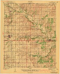 1941 Severy1941 Print · USGSGreenwood and Elk Counties are shown here just before the Second World War, centered on the busy rail junction at Severy. Researchers can trace dozens of rural schoolhouses and cemeteries, including the Lone Star Cem, Antioch Ch, and the vanished settlement at Ashley.3 unique versions available
 - 1942 Map of Fredonia
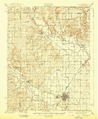 1942 Fredonia1942 Print · USGSThe rail crossroads at Fredonia and the winding river valleys of Wilson County are captured here just before the mid-century. Genealogists can trace rural life through dozens of local landmarks like Old Taylor Cem, Coyville, and the Needmore Sch.
 - 1943 Map of Fredonia
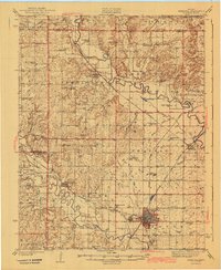 1943 Fredonia1943 Print · USGSSoutheast Kansas at the dawn of the 1940s reveals a landscape of river-valley towns and dozens of rural school districts. Genealogists can trace family footprints through numerous country schools like Ten Penny Sch and the Jackson Cem near New Albany.2 unique versions available
 - 1947 Map of Lawrence, 1954 Print
 1947 Lawrence1954 Print · USGSEastern Kansas and western Missouri thrive in the late 1940s, showing a landscape defined by major river valleys and a dense railway network. Genealogists can trace family settlements from Lawrence to Greenwood and locate landmarks like Olathe Navy and Lake Lotawana.
 - 1947 Map of Joplin, 1954 Print
 1947 Joplin1954 Print · USGSThe borderlands of Missouri, Kansas, and Oklahoma are shown here during the late 1940s, a period of heavy industrial and military activity. Researchers can trace the extensive Tri-State Mining District, the layout of Camp Crowder, and local landmarks like Mount Hope Cem.
 - 1949 Map of Joplin
 1949 Joplin1949 Print · USGSThe Kansas-Missouri borderlands thrive in the late 1940s, showing a robust network of railroad towns and river valleys. Researchers can trace historic rail lines like the Missouri Pacific RR and locate rural centers such as Chanute, Iola, and Fort Scott.
End of results
Showing maps 1-6 of 6
Top cities of Greenwood County
- Eureka historical maps
- Madison historical maps
- Severy historical maps
- Hamilton historical maps
- Quincy historical maps
- Fall River historical maps
See more
Frequently asked questions
- What are the different types of historical maps available for Greenwood County?
- What is the oldest map of Greenwood County?
- Where can I purchase historical maps of Greenwood County for my home or office?
- Where can I download high-res historical maps of Greenwood County?
- Are there historical topographic maps available for Greenwood County?
- Is there historical aerial imagery available for Greenwood County?
- Where are historical maps of Greenwood County sourced from?