1970s Maps of Greenwood County, Kansas
Explore 15 historic maps of Greenwood County from the 1970s. These maps offer a rare glimpse into what life looked like during the 1970s — showing old roads, neighborhoods, homes, and landmarks that have changed or disappeared over time.
Whether you're researching your family's past, planning a metal detecting trip, or studying how Greenwood County's landscape evolved across the 1970s, these high-resolution maps are a powerful tool for exploring the history of this region.
- Focus on a specific era: All maps on this page are from the 1970s, giving you a focused view of this time period.
- See what’s changed: Compare century-old streets, trails, and buildings to today's modern landscape using overlays and satellite layers.
- Research with precision: Use these maps for genealogy, historical research, land use analysis, or educational projects.
- View, download, or print: Maps are fully viewable online in high resolution, and can be downloaded or printed for your own records.
Start exploring Greenwood County's history through authentic maps from the 1970s. This is your window into the past.
Greenwood County, KS maps
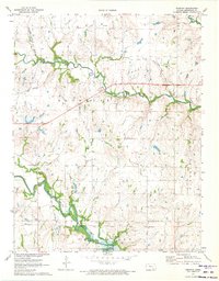
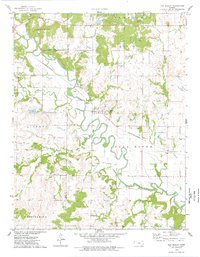
(15)- 1971 Map of Eureka, 1973 Print
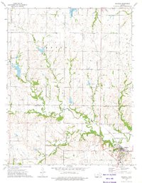
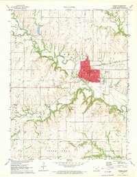 1971 Eureka1973 Print · USGSEureka stands at the junction of two major rail lines in the early seventies, nestled along the loops of the Fall River. Researchers can locate the Old Indian Treaty Boundary, the Greenwood Cemetery, and local landmarks like the Random Sch.
 - 1971 Map of Reece, 1973 Print
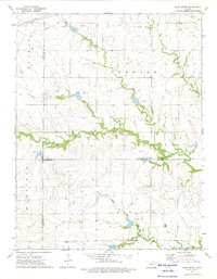
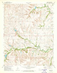 1971 Reece1973 Print · USGSGreenwood County's prairie landscape is recorded here in the early seventies, centered on the railroad town of Reece. Researchers can trace the Old Indian Treaty Boundary and locate local landmarks like the Reece Cem and the Reece Oil Field.
 - 1971 Map of Lapland, 1973 Print
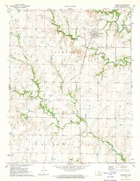
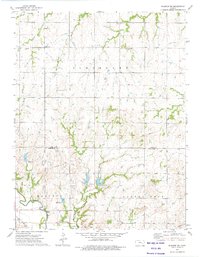
 1971 Lapland1973 Print · USGSGreenwood County farmland and petroleum fields are captured here in the early seventies as the region maintained its rural character. Genealogists and local researchers can locate the Upper Fall River Ch & Cem, the settlement of Lapland, and various oil operations like the Polhamas Oil Field.
 - 1971 Map of Hamilton, 1973 Print
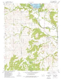
 1971 Hamilton1973 Print · USGSHamilton and the surrounding Flint Hills region are captured in the early seventies, showcasing a landscape of prairie creeks and railroad operations. Genealogists can locate family landmarks such as Township Cem, Homer Creek Cem, and the Utopia Community Ch.
 - 1971 Map of Tonovay, 1973 Print
 1971 Tonovay1973 Print · USGSGreenwood County, Kansas, was defined by its prairie drainages and rail lines in the early seventies. Genealogists and historians can trace the Indian Treaty Boundary, the small settlement of Tonovay, and numerous industrial sites including Oil Wells and Gravel Pits.
 - 1971 Map of Eureka NE, 1973 Print
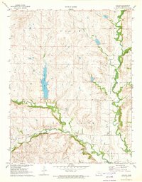
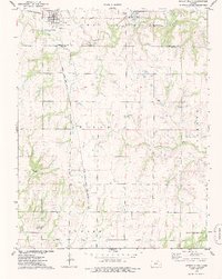
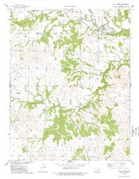
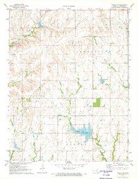 1971 Eureka NE1973 Print · USGSGreenwood County at the start of the 1970s shows a landscape of cattle ranching and oil production centered around the new Eureka City Lake. Researchers can trace old family properties near Highland Cem or locate the various Oil Wells and the Thrall Field.
 - 1973 Map of Shaw Creek, 1975 Print
 1973 Shaw Creek1975 Print · USGSThe Kansas Flint Hills of the early 1970s are captured here where the borders of Lyon, Chase, and Greenwood counties meet. Genealogists and researchers can locate the settlement of Kenbro and trace early petroleum activity through numerous Oil Wells and the winding Verdigris River.
 - 1973 Map of Madison NE, 1975 Print
 1973 Madison NE1975 Print · USGSLyon and Greenwood counties meet in this 1970s landscape defined by the winding Verdigris River and its upland oil fields. Genealogists and historians can trace an Old Railroad Grade and four distinct burial sites, including Fairview Cem and Lena Valley Cem.
 - 1973 Map of Madison, 1975 Print
 1973 Madison1975 Print · USGSMadison and the surrounding Greenwood County countryside appear here in the early 1970s, at a time when the local economy was driven by the Oil Field and the Atchison Topeka and Santa Fe railroad. Genealogists can trace several local burial sites, including Zion Cem and Blakely Cem, alongside the winding Verdigris River.
 - 1975 Map of Severy North, 1978 Print
 1975 Severy North1978 Print · USGSGreenwood County in the mid-seventies shows a landscape shaped by the Fall River Lake and its surrounding wildlife areas. Researchers can trace rural rail lines like the St Louis San Francisco and locate local landmarks such as Climax, Twin Grove Cem, and Honey Creek Bridge.
 - 1975 Map of Severy South, 1978 Print
 1975 Severy South1978 Print · USGSThe rail junction at Severy and the nearby settlement of Fiat define this 1970s look at the Greenwood and Elk County border. Researchers can trace rural infrastructure from the Sunflower Grange Hall to oil wells and the Pleasant View Cemetery.
 - 1975 Map of Coyville, 1978 Print
 1975 Coyville1978 Print · USGSSoutheast Kansas in the mid-seventies reveals a river valley defined by both its agricultural roots and modern water management. Genealogists and historians can trace the legacy of local families through Carlisle Cem and Hunter Cem, or locate the Old Railroad Grade near Coyville.
 - 1975 Map of New Albany, 1978 Print
 1975 New Albany1978 Print · USGSNew Albany sits at the crossroads of the river and rail in the mid-1970s, where the prairie begins to break into timbered creek bottoms. Genealogists and historians can locate family burial sites like Weakley Cem and St Francis Cem while tracing the St Louis-San Francisco rail line.
 - 1975 Map of Fall River, 1978 Print
 1975 Fall River1978 Print · USGSThe rural border of Greenwood and Elk counties comes into focus during the mid-seventies, centered on the river crossing at Fall River. Genealogists and local historians can trace family sites like Mount Zion Ch, the Wade Cem, and the rail corridor of the ST LOUIS - SAN FRANCISCO.
 - 1975 Map of Fall River Lake, 1978 Print
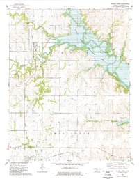
 1975 Fall River Lake1978 Print · USGSThe Fall River valley in Greenwood County was significantly reshaped by the mid-1970s following the creation of the reservoir. Genealogists and local historians can trace legacy sites like Browns Chapel Cem and the rail line of the St L-SF near the Fall River State Park.
End of results
Showing maps 1-15 of 15
Top cities of Greenwood County
- Eureka historical maps
- Madison historical maps
- Severy historical maps
- Hamilton historical maps
- Quincy historical maps
- Fall River historical maps
See more
Frequently asked questions
- What are the different types of historical maps available for Greenwood County?
- What is the oldest map of Greenwood County?
- Where can I purchase historical maps of Greenwood County for my home or office?
- Where can I download high-res historical maps of Greenwood County?
- Are there historical topographic maps available for Greenwood County?
- Is there historical aerial imagery available for Greenwood County?
- Where are historical maps of Greenwood County sourced from?